Geography of Ireland
The highest peak is Carrauntoohil (Irish: Corrán Tuathail), which is 1,039 metres (3,409 ft) above sea level.
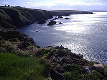
The western coastline is rugged, with many islands, peninsulas, headlands and bays, while the southern and northern coasts feature a smaller number of substantial sea inlets, such as Lough Foyle and Cork Harbour; no part of the land is more than around 110 km (68 mi) from the sea.
It was administratively divided into 32 counties, gathered in 4 provinces, though current arrangements, especially in Northern Ireland, differ from this model.
The island is almost bisected by the River Shannon, which at 360.5 km (224 mi) with a 102.1 km (63 mi) estuary is the longest river in Ireland and flows south from County Cavan in the province of Ulster to form the boundary between Connacht and Leinster, and later Munster, and meet the Atlantic just south and west of Limerick.
The oldest known Irish rock is about 1.7 billion years old and is found on Inishtrahull Island off the north coast of Inishowen[4][5] and on the mainland at Annagh Head on the Mullet Peninsula.
[7][8] Ireland's geological history includes a wide range of elements, from volcanism and tropical seas to the last glacial period.
Ireland was formed in two distinct parts, which slowly joined, uniting about 440 million years ago.
[14] Protracted erosion also means most of the Paleogene and Neogene sediments have been eroded away or, as known in a few cases, buried by Quaternary deposits.
[15] Before the Quaternary glaciations affected Ireland the landscape had developed thick weathered regolith on the uplands and karst in the lowlands.
[15][16] While some have argued for an origin in marine planation, others regard these surfaces as peneplains formed by weathering and fluvial erosion.
Not only is their origin disputed but also their actual extent and the relative role of sea-level change and tectonics in their shaping.
[17] The highest peak Carrauntoohil, at 1,038.6 m (3,407 ft) high,[21] is in the MacGillycuddy's Reeks, a range of glacier-carved sandstone mountains.
In the Republic of Ireland are over 74,000 kilometres (46,000 mi) of rivers and streams, more than 125,000 hectares (310,000 acres) of lake and over 3,000 hectares (7,400 acres) of reservoirs; these are not evenly distributed—over 30% of the watercourse length is found in Counties Cork, Donegal and Mayo, while Counties Mayo and Galway hold over 40% of the total lake area.
[29] Lough Neagh, in Ulster,[21] is the largest lake in Ireland and Britain with an area of 392 km2 (151 sq mi).
[37][38] Loop Head is the headland at which County Clare comes to a point on the west coast of Ireland, with the Atlantic on the north, and the Shannon estuary to the south.
[49] The Hebrides off Scotland and Anglesey off Wales were grouped with Ireland ("Hibernia") by the Greco-Roman geographer Ptolemy.
[55] As the continental shelf extends far to the west and southwest, the larger of the two jurisdictions on the island has extensive seabed claims, exceeding 880,000 square kilometres (340,000 sq mi), more than 10 times the land area.
[59] The influence of the North Atlantic Current also ensures the coastline of Ireland remains ice-free throughout the winter.
In making its recommendations on changes to Dáil constituencies, the Electoral Commission is required to avoid breaching county boundaries as far as practicable.
[90] The island's total population was nearly 7 million people concentrated in the east and south, particularly in Dublin, Belfast, Cork and their surrounding areas in the 2011 (RoI) and 2012 (NI) Census.
[96]: 5–10 [97] Blanket bogs are essentially a product of human activity aided by the moist Irish climate, having formed on sites where Neolithic farmers cleared trees for farming.
[98] As the land so cleared fell into disuse, the soil began to leach and become more acidic, producing a suitable environment for the growth of heather and rushes.
Other mineral deposits with actual or potential commercial value include gold, silver, gypsum, talc, calcite, dolomite, roofing slate, limestone aggregate, building stone, sand, and gravel.
[108] In March 2012, the first commercial oil well was drilled 70 km (43 mi) off the Cork coast by Providence Resources, renamed Barryroe Offshore.
[109] At the time, Providence's executive Tony O'Reilly Jr. said, "It's a defining moment for the Irish offshore oil and gas industry.
[111] However, in 2023, the Department of the Environment, Climate and Communications declined approval of the "Lease Undertaking" that would be necessary to finish appraisal drilling, and Barryroe Offshore Energy will now wind down their business by a voluntary liquidation so the field may not be developed.
[114] Bellacorick wind farm, built by Bord na Móna in 1992, was the first Irish wind farm with an individual turbine capacity of 0.3MW which compared with the current capacity of 4–5MW means that when turbines age out, replacements will produce significantly more power per installation.
[115] A floating 400MW wind farm off the coast of Northern Ireland was proposed for the North Channel in 2022 to be operating by 2029.
[117] In November 2023, EDF Renewables announced their Carrowkeel Wind Farm which will be a 30MW project for County Roscommon for completion in 2028 which should power more than 20,000 homes.
Opposition to the visual impact of solar farms, and other forms of renewable energy, was noted as hindering some projects.