The supergroup consists of a sequence of units, mostly of nonmarine origin, deposited between the Late Carboniferous and Early Jurassic, a period of about 120 million years.
[3][6] Its strata, which consist mostly of shales and sandstones,[7] record an almost continuous sequence of marine glacial to terrestrial deposition from the Late Carboniferous to the Early Jurassic.
[8] Fossils include plants (both macro-fossils and pollen), rare insects and fish, common and diverse tetrapods (mostly therapsid reptiles, temnospondyl amphibians, and in the upper strata dinosaurs), and ichnofossils.
[5] Closure of the rift valley, starting 330 million years ago, resulted from the development of a subduction zone along the southern margin of Gondwana, and the consequent drift of the Falkland Plateau back towards Africa, during the Carboniferous and Early Permian periods.
Sedimentation, beginning with glacial deposits from the north, but later from the Falkland Mountains to the south, into this depression formed the Karoo Supergroup.
[5][11] This layer of tillite, traces of which can be found over a wide area of Southern Africa, India, and South America provided crucial early evidence in support of the Theory of Continental Drift.
Rivers draining mountains to the north of the Karoo Sea formed large swampy deltas in which plants belonging to the Glossopteris flora flourished.
They consist largely of shales and sandstones,[16] and extend over the entire former Karoo Sea, but the southerly deposits do not contain coal, even though rivers from the Cape Fold Mountains formed small deltas.
[11] During the Ecca period the Falklands Plateau collided and then fused with Southern Africa, forming a vast range of mountains to the south of the Cape Fold Belt.
The earthquakes that accompanied the formation of the Cape Mountains therefore initiated frequent underwater mud- and rock-slides, forming fan-shaped accumulations of turbidites, which can be seen in the south west corner of the Karoo today (see photograph lower down on the right) the Ecca group also has its members that are named based on the lithologies of the locality they are in .
[5][15][17] Turbidites have for some time been recognized as petroleum producing rocks, because the underwater avalanches that cause these deposits often carry organic matter from close to the coastline, especially near river estuaries and deltas, into the anoxic depths of adjoining troughs.
The turbidites in the Ecca formation of the Tanqua and Laingsburg Karoo regions have thus, recently, come under scrutiny by the petroleum industry and geologists, who have found them to have rich and readily accessible deposits of oil and gas.
Several Mississippi-like rivers flowed over the silted up Karoo Basin from the south, creating rich new habitats for a variety of flora and fauna.
[5] During the course of the laying down of the 6 km thick Beaufort deposits, the massive end-Permian mass extinction, 251 million years ago, extinguished about 96% of all species alive at that time.
With time the Beaufort deposits became more fine-grained once again, probably indicating a recovery of the vegetation in the Karoo, and with it the appearance of a wide range of new species, including the dinosaurs, and true mammals during the late Triassic – early Jurassic.
These flows piled up in rapid succession over 2 million years, to form a single continuous 1 to 1.6 km thick lava layer.
This outpouring of lava coincided with uplifting of the Southern African portion of Gondwana, and the formation of rift valleys along what were to become the sea borders of the subcontinent.
As these rift valleys widened they became flooded to form the proto-Indian and Southern Atlantic Oceans, as Gondwana fragmented into today's separate continents of South America, Africa, Antarctica, Australia, India, Madagascar and Arabia.
Nearly all of the Drakensberg lavas were eroded away, leaving a remnant in Lesotho, several small patches on the Springbok Flats in the north of the country, and in the Lebombo mountains along the Mozambique border.
The dykes, or vertical fissures which brought the lava to the surface stand out today as linear ridges extending across large stretches of the Karoo.
Some of the eroded material from the interior was trapped between the Cape Fold Mountains to the south during the Cretaceous Period to form the Enon Formation and similar deposits near the coast of KwaZulu-Natal, north of Richards Bay.
A timeline of the Earth's geological history, with an emphasis on events in Southern Africa. The green block labeled
K
indicates when the Karoo Supergroup was deposited, in relation to the
Cape supergroup
,
C
, immediately before it. The
W
indicates when the
Witwatersrand supergroup
was laid down, very much further in the past. The graph also indicates the period during which
banded ironstone formations
were formed on Earth, indicative of an
oxygen-free atmosphere
. The Earth's crust was wholly or partially molten during the
Hadean
Eon; the oldest rocks on Earth are therefore less than 4000 million years old. One of the first microcontinents to form was the
Kaapvaal Craton
, which forms the foundation of the north-eastern part of the country. The assembly and break-up of
Gondwana
are, in terms of the Earth's and South Africa's geological history, relatively recent events.
Southern
Gondwana
during the
Cambrian
-
Ordovician
Periods. Today's continents into which this Supercontinent eventually broke up, are indicated in brown. A rift developed about 510 million years ago, separating Southern Africa from the Falkland Plateau. Flooding of the rift formed the Agulhas Sea. The sediments which accumulated in this shallow sea consolidated to form the
Cape Supergroup
of rocks, which form the Cape Fold Belt today.
[
5
]
[
10
]
[
11
]
This portion of Gondwana was probably located on the opposite side of the South Pole from Africa's present position,
[
12
]
but compass bearings are nevertheless given as if Africa was in its present position.
A schematic geological map of the outcrops of the Karoo Supergroup rocks in Southern Africa. The location and approximate structure of the Cape Fold Mountains are also diagrammatically indicated for reference purposes
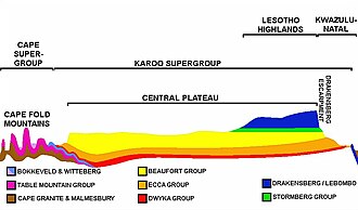
An approximate SW-NE geological cross section through South Africa, with the
Cape Peninsula
(with
Table Mountain
) on left, and north-eastern
KwaZulu-Natal
on the right. Diagrammatic and not to scale. The color code of the Karoo Supergroup is the same as in the illustration above.
A north-south cross-section through the Agulhas Sea (see above). The brown structures are continental plates, the thick black layer on the left is paleo-Pacific Oceanic plate, red indicates the
upper mantle
, and blue indicates flooded areas or ocean. The top illustration depicts the geology about 510 million years ago, with the sediments which would eventually form the Cape Supergroup settling in the Agulhas Sea. The middle illustration depicts the Falkland Plateau drifting northwards once again to close the Agulhas Sea, causing the Cape Supergroup to be rucked into a series of folds, running predominantly east–west. The lowest illustration shows how subduction of the paleo-Pacific Oceanic plate under the Falkland Plateau, during the Early Permian period, raised a massive range of mountains. These eventually eroded into the Karoo Sea, forming, especially, the
Beaufort Group
of the Karoo Supergroup.
Turbidites
are deposited in deep water at the bottom of the edges of continental shelves or similar structures in deep lakes, such as the south-western Karoo Sea about 300 million years ago. They are the result of
underwater avalanches
of mud and sand cascading down the steep slope of the edge of the shelf. When the avalanche settles in the deep water trough, the sand and other coarse material settles first, then the mud and eventually the finest particles. Organic matter that came down with the avalanche ends up in the turbidite in an anoxic (oxygen free) environment where it is converted to
petroleum
(oil and gas).
An Ecca mountain in the
Tanqua Karoo
, with multiple turbidite fans, indicating that the south-western portion of Karoo Sea was very deep, with steep slopes leading up to the shore line. The underwater avalanches were probably triggered by frequent earthquakes as the
Cape Fold Mountains
were being formed towards the south. The Ecca Turbidite deposits should not be confused with the
dolerite
sills found further inland (illustrated and described lower down, on the right, in the article) . The turbidites can be recognized at close quarters by the fact that the lowermost portion of each layer tends to be made up of sandstone which gradually grades into fine siltstone at the top of the layer.
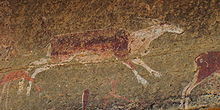
San rock painting of an eland in a
Clarens Formation
cave in the UKhahlamba Drakensberg Park of
KwaZulu-Natal
close to the Lesotho border.
Panorama of the Drakensberg in
Giant's Castle
region, on the KwaZulu-Natal/Lesotho border. The uppermost layer of this portion of the
Great Escarpment
is formed by the 1400 m thick Drakensberg Lavas, which rest on the Clarens Formation rocks.
Typical flat topped Karoo Koppies in the
Cradock
region of the Great
Karoo
. The
dolerite
sills
are harder and more erosion resistant than the Beaufort shales into which they were intruded, giving these hills their tabletop summits and stepped sides.