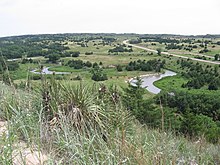
Sandhills (Nebraska)
The World Wide Fund for Nature (WWF) designated the Sandhills as an ecoregion, distinct from other grasslands of the Great Plains.
Paleoclimate proxy data and computer simulations reveal that the Nebraska Sandhills likely had active sand dunes as recently as the Medieval Warm Period, when temperatures in the North Atlantic region[5][6] were about 1 °C (1.8 °F) warmer than the current climate.
[7][8] Current global warming may make the grassland climate more unstable, giving way to desert given more fires, mild drought and erosion; UCAR simulations based on evapotranspiration support a Palmer Drought Index lower than -15, many times more severe than Texas during the Dust Bowl.
[2] Minimal crop production has led to limited land fragmentation; the resulting extensive and continuous habitat for plant and animal species has largely preserved the biodiversity of the area.
[citation needed] The Sandhills' thousands of ponds and lakes are spring-fed surface water areas of the Ogallala Aquifer.
The natural reservoirs are also primarily confined to a few regions of the Sandhills with the vast majority located in northern Garden County.
Windmills and solar-powered submersible electric pumps fed by the easily-accessible aquifer filling cement-bottom steel stock tanks up to 30 feet in diameter are used to supply livestock with cool, fresh water on a daily basis.
Over time, the trees spread to replace large areas of grassland, leading to ecosystem collapse on ranchlands.
Grazing and land management practices used by Sandhills ranchers have reduced natural erosion, thus destroying some of the plant's habitat.
Better land management and grazing practices by the ranchers of the region have led to less erosion over time, which has kept the natural landscape of the area mostly intact.
Due to the warm stagnant nature of both alkaline and freshwater lakes throughout the region, coupled with the wetland marsh areas, mosquito populations increase during the summer months.
[citation needed] The Sandhills are part of the Central Flyway for many species of migratory birds, and the region's many bodies of water give them places to rest.
[17] The Nature conservancy's Niobrara Valley Preserve in Cherry, Brown, and Keya Paha counties covers 60,000 acres (202 km2) and includes a 25-mile (40 km) stretch of the river.
"[G]iven the concentration of concerns regarding the environmental sensitivities of the current proposed route through the Sand Hills area of Nebraska, the Department has determined it needs to undertake an in-depth assessment of potential alternative routes in Nebraska [...] The comments were consistent with the information in the final Environmental Impact Statement (EIS) about the unique combination of characteristics in the Sand Hills (which includes a high concentration of wetlands of special concern, a sensitive ecosystem, and extensive areas of very shallow groundwater) and provided additional context and information about those characteristics.