Somerset County, Pennsylvania
Southwestern Pennsylvania began as a huge area called Cumberland County.
[5] George Washington passed through the area of Somerset County on a scouting expedition in late 1753, just before the outbreak of the French and Indian War.
This 200-mile stretch from Carlisle to what is now Pittsburgh was created by Brigadier General John Forbes in the British Expedition of 1758 to capture the French Fort Duquesne.
Forbes Road was one of two great western land routes cut through the wilderness to create supply lines from the east.
The earliest permanent white settlement in what is now Somerset County is a region known as Turkeyfoot.
Once it became evident that the passengers might gain control, the hijackers rolled the plane and intentionally crashed it.
The USS Somerset, a U.S. Navy warship, was named in commemoration of the Flight 93 tragedy.
[3] In July 2002, Somerset County again made worldwide news when nine coal miners were rescued from several hundred feet underground at the Quecreek mine after an intense multi-day struggle.
Somerset County is one of the 423 counties served by the Appalachian Regional Commission,[11] and it is identified as part of "Greater Appalachia" by Colin Woodard in his book American Nations: A History of the Eleven Rival Regional Cultures of North America.
[13] [citation needed] The county's elevation and general proximity to both the Great Lakes and the Atlantic Ocean causes snow from both Nor'easters and lake effect upslope snow events to fall from late October through early April.
Mount Davis, the highest natural point in the state of Pennsylvania at 3,213 feet (979 m), is located in the southern part of the county.
The county has a warm-summer humid continental climate (Dfb) and average monthly temperatures in Somerset borough range from 24.5 °F in January to 67.1 °F in July.
[14] Somerset County is situated along the eastern border of the Allegheny Plateau physiographic province, which is characterized by gently folded to flat-lying sedimentary rocks of middle to late Paleozoic age.
The eastern border of the county is approximately at the Allegheny Front, a geological boundary between the Allegheny Plateau and the Ridge and Valley Province (characterized by folded and faulted sedimentary rocks of early to middle Paleozoic age).
Structurally, Somerset County has many gentle folds, the axes of which trend roughly north-northeast.
Patterned ground typical of tundra is still visible at Mount Davis, although it is somewhat obscured by vegetation.
In the southeast, Wills Creek flows east into Bedford County and then into Maryland where it joins the Potomac River.
[18] There are many small, deep natural gas fields in the northwestern part of the county.
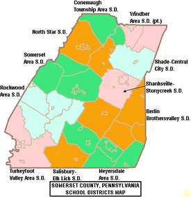
[31] School districts include:[33] The Mountain Playhouse in Jennerstown, Pennsylvania, was one of the nation's first "summer-stock" theaters.
Under Pennsylvania law, there are four types of incorporated municipalities: cities, boroughs, townships, and, in at most two cases, towns.
The following boroughs and townships are located in Somerset County: Census-designated places are geographical areas designated by the U.S. Census Bureau for the purposes of compiling demographic data.