Lycoming County, Pennsylvania
[a] Lycoming County comprises the Williamsport metropolitan statistical area.
The following counties have been formed from land that was once part of Lycoming County: Armstrong, Bradford, Centre, Clearfield, Clinton, Indiana, Jefferson, McKean, Potter, Sullivan, Tioga, Venango, Warren, Forest, Elk and Cameron.
Brule descended the West Branch Susquehanna River and was held captive by a local Indian tribe near what is now Muncy before escaping and returning to Canada.
The road followed the Great Shamokin Path from Fort Augusta in what is now Sunbury to Bald Eagle Creek near modern-day Lock Haven.
Andrew Gregg was elected to represent Lycoming County in the United States Congress, William Hepburn was voted to the Pennsylvania State Senate and Flavel Roan, Hugh White and Robert Martin served as representatives in the Pennsylvania General Assembly.
[3] 1823: The county government funded the construction of the first bridges over Loyalsock and Lycoming Creeks.
The county has a humid continental climate which is warm-summer (Dfb) except in lower areas near the river which are hot-summer (Dfa).
[5] Lycoming County is divided between the Appalachian Mountains in the south, the dissected Allegheny Plateau (which also appears mountainous) in the north and east, and the valley of the West Branch Susquehanna River between these.
The river then flows generally east and a little north with some large curves for 15 miles (24 kilometres) to the city of Williamsport, followed by the borough of Montoursville (both on the north bank) as well as the boroughs of Duboistown and South Williamsport (on the south bank).
The river flows just north of Bald Eagle Mountain (one of the northernmost ridges of the Ridge-and-valley Appalachians) through much of its course in Lycoming County, but it passes the end of the mountain and turns south just before the borough of Muncy (on the east bank).
The major creeks of Lycoming County are all tributaries of the West Branch Susquehanna River.
The river receives it at the village of Allenwood in Gregg Township in Union County.
The Williamsport Regional Airport has commercial flights to Washington D.C.,[20] and a FBO for private jets and charters.
There is also the Jersey Shore Airport, which only has a grass runway and can only handle light aircraft.
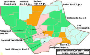
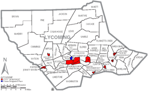
The following cities, boroughs and townships are located in Lycoming County: Census-designated places are geographical areas designated by the U.S. Census Bureau for the purposes of compiling demographic data.