Westmoreland County, Pennsylvania
[3] Westmoreland County is one of the 423 counties served by the Appalachian Regional Commission,[4] and it is identified as part of "Greater Appalachia" by Colin Woodard in his book American Nations: A History of the Eleven Rival Regional Cultures of North America.
[15] Chart of Voter Registration The Democratic Party historically dominated county-level politics between the New Deal realignment and the turn of the century; however, Westmoreland has trended Republican at the national and statewide levels in the 21st century (in direct lockstep with most other Appalachian counties).
In 2004 Republican Bob Regola flipped the 39th Senate district by beating out incumbent Allen Kukovich.
Then in 2008, Republican Tim Krieger picked up the 57th House district left open by the retirement of Democratic state representative Tom Tangretti.
In 2010, both Pat Toomey and Tom Corbett won Westmoreland in their statewide bids.
Also, the GOP gained control of two more State House districts, the 54th with Eli Evankovich and the 56th with George Dunbar.
In 2023 Republicans retained their majority on the Board of Commissioners and held every row office.
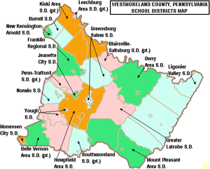
School districts:[21] According to EdNA[22] Coal mining became a major industry in the county after the Civil War, followed by the expansion of iron, steel, and glass manufacturing.
[25][26] At one point, company "coal patches" (towns built for miners) represented about one-third of the county's settlements.
[27] A major strike by coal miners represented by the United Mine Workers of America took place in 1910–1911.
[28] In 2020, the top industries in the county were health care and social services (16.3% of jobs), manufacturing (13.8%), and retail trade (13.7%).
Under Pennsylvania law, there are four types of incorporated municipalities: cities, boroughs, townships, and, in at most two cases, towns.
The following cities, boroughs, and townships are located in Westmoreland County: Census-designated places are geographical areas designated by the U.S. Census Bureau for the purposes of compiling demographic data.