Colorado River
[11] For the first 250 miles (400 km) of its course, the Colorado carves its way through the mountainous Western Slope, a sparsely populated region defined by the portion of the state west of the Continental Divide.
[16] In Utah, the Colorado flows primarily through the "slickrock" country, which is characterized by its narrow canyons and unique "folds" created by the tilting of sedimentary rock layers along faults.
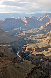
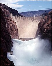
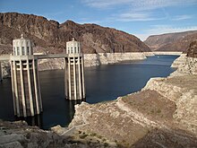
[25] At the lower end of Grand Canyon, the Colorado widens into Lake Mead, the largest reservoir in the continental United States, formed by Hoover Dam on the border of Arizona and Nevada.
[26] Below the dam the river passes under the Mike O'Callaghan–Pat Tillman Memorial Bridge—which at nearly 900 feet (270 m) above the water is the highest concrete arch bridge in the Western Hemisphere[27]—and then turns due south towards Mexico, defining the Arizona–Nevada and Arizona–California borders.
Joseph C. Ives, who surveyed the lower river in 1861, wrote that "the shifting of the channel, the banks, the islands, the bars is so continual and rapid that a detailed description, derived from the experiences of one trip, would be found incorrect, not only during the subsequent year, but perhaps in the course of a week, or even a day.
[33] Below Imperial Dam, only a small portion of the Colorado River makes it beyond Yuma, Arizona, and the confluence with the intermittent Gila River—which carries runoff from western New Mexico and most of Arizona–before defining 24 miles (39 km) of the Mexico–United States border.
[36] Before 20th-century development dewatered the lower Colorado, a major tidal bore was present in the delta and estuary; the first historical record was made by the Croatian missionary in Spanish service Father Ferdinand Konščak on July 18, 1746.
[82] Upstream of the massive Hoover and Glen Canyon Dams, inflows to Lake Powell still experience distinct spring highs and winter lows, though overall volumes have been reduced due to Upper Basin water diversions.
[92] At Morelos Dam, the remaining flow is diverted to irrigate the Mexicali Valley, leaving the Colorado River Delta almost entirely dry except for small amounts of agricultural wastewater.
[105] Sediments carried from the plateau by the Colorado River created a vast delta made of more than 10,000 cubic miles (42,000 km3) of material that walled off the northernmost part of the gulf in approximately 1 million years.
[112] Small numbers of Paleo-Indians of the Clovis and Folsom cultures inhabited the Colorado Plateau as early as 10,000 BCE, with populations beginning to increase in the Desert Archaic period (6000 BCE–0 CE).
The Puebloan people built many multi-story pueblos or "great houses", and developed complex distribution systems to supply drinking and irrigation water in Chaco Canyon in northwestern New Mexico[118] and Mesa Verde in southwest Colorado.
[121] Puebloan and Hohokam settlements were abruptly abandoned in the 1400s CE, due both to over-exploitation of natural resources such as timber, and severe drought that made it impossible to maintain irrigation systems.
We are three-quarters of a mile in the depths of the earth, and the great river shrinks into insignificance, as it dashes its angry waves against the walls and cliffs, that rise to the world above; they are but puny ripples, and we but pigmies, running up and down the sands, or lost among the boulders.
[180] The Denver and Rio Grande Western Railroad (D&RGW) quickly expanded into this area to serve mining boomtowns, crossing the Rockies to the south via the Black Canyon of the Gunnison River.
[183][156]: 78 In 1879 a group of Mormon settlers made their way to southeastern Utah, blasting the precarious Hole in the Rock Trail to cross the Colorado River at Glen Canyon, subsequently establishing the community of Bluff.
The D&SL completed a rail line into the upper headwaters of the Colorado River and blasted the Moffat Tunnel under the Continental Divide, but ran out of money before even reaching Utah.
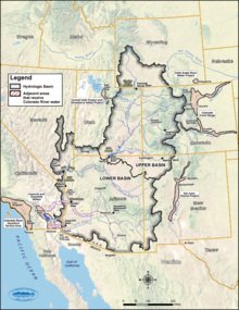
The Upper and Lower Basin were each allocated 7.5 million acre-feet (9.3 km3) of water per year, a figure believed to represent half of the river's annual flow at Lee's Ferry.
[220] The Colorado River delta region in Mexico became a favored place for Americans to invest in agriculture in the late 19th century when Mexican President Porfirio Díaz welcomed foreign capital to develop the country.
[225] It took seven attempts, more than $3 million, and two years for the railroad, the CDC, and the federal government to permanently block the breach and restore the river's original course – but not before part of the Imperial Valley was flooded under a 45-mile-long (72 km) lake, today's Salton Sea.
The canal's intake is located at Imperial Dam, 20 miles (32 km) above Yuma, Arizona, which diverts the majority of the Colorado's flow with only a small portion continuing to Mexico.
[272] In late 2010, Lake Mead was approaching the "drought trigger" elevation of 1,075 feet (328 m), at which water supplies to Arizona and Nevada would be reduced in accordance with the Colorado River Compact.
[286] On June 14, 2022, Bureau of Reclamation Commissioner Camille Touton told the Senate Committee on Energy and Natural resources that additional cuts of 2–4 million acre-feet were required to stabilize reservoir levels in 2023.
[287] When the states were unable to come to an agreement about how to share the proposed cuts, Reclamation began the legal steps to unilaterally reduce releases from Hoover and Glen Canyon Dams in 2023.
[288] As of December 2022 the lower basin states of Nevada, Arizona, and California had not agreed on how to reduce water use by the approximately 30% required to keep levels in lakes Mead and Powell from crashing.
[300] More than 1,600 species of plants grow in the Colorado River watershed, ranging from the creosote bush, saguaro cactus, and Joshua trees of the Sonoran and Mojave Deserts to the forests of the Rocky Mountains and other uplands, composed mainly of ponderosa pine, subalpine fir, Douglas-fir and Engelmann spruce.
Today's desiccated delta, at only a fraction of its former size, no longer provides suitable habitat, and populations of fish, shrimp and sea mammals in the gulf have seen a dramatic decline.
[320] Large dams such as Hoover and Glen Canyon typically release water from lower levels of their reservoirs, resulting in stable and relatively cold year-round temperatures in long reaches of the river.
[322] These flow patterns have also made the Colorado more dangerous to recreational boaters; people are more likely to die of hypothermia in the colder water, and the general lack of flooding allows rockslides to build up, making the river more difficult to navigate.
[326] This pulse reached the sea on May 16, 2014, marking the first time in 16 years that any water from the Colorado flowed into the ocean, and was hailed as "an experiment of historic political and ecological significance" and a landmark in U.S.–Mexican cooperation in conservation.