Hurricane Katia (2011)
The storm was responsible for two deaths in the United Kingdom: one when a tree fell on a vehicle in County Durham, and another during a multi-car accident on the M54 motorway resulting from adverse weather conditions.
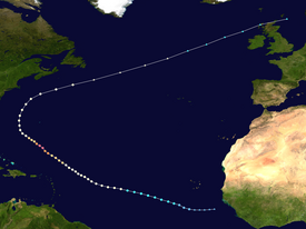
On August 27, the National Hurricane Center (NHC) began monitoring a large mass of convection associated with a tropical wave just off the western coast of Africa.
[1] An area of low pressure formed in association with the disturbance the following day,[2] gaining sufficient organization to be declared a tropical depression by 06:00 UTC on August 29 approximately 430 miles (690 km) southwest of the southernmost Cabo Verde Islands.
Twelve hours later, the cyclone further intensified into a Category 4 hurricane and attained peak winds of 140 mph (230 km/h) and a minimum barometric pressure of 942 mbar (942 hPa; 27.8 inHg) as its eye warmed, deep convection became much more symmetric about the center, and upper-level outflow expanded.
Increasing southwesterly flow resultant from an upper-level trough pushing eastward across the United States caused Katia to slow in forward motion and recurve northeast or east-northeast through September 9.
[3] Deep convection in association with the storm decreased and its circulation merged with a frontal system,[12] indicating that Katia had completed transition into an extratropical cyclone by 12:00 UTC on September 10 while located about 290 miles (470 km) south-southeast of Cape Race, Newfoundland.
[14] On September 4, the NHC noted that large swells likely to cause life-threatening rip current conditions were expected to impact the East Coast of the United States over subsequent days.
[17] After transitioning into a post-tropical cyclone, Katia moved quickly across the North Atlantic and toward Europe, prompting the Met Office to begin warnings citizens for potential impacts over subsequent days on September 9.
[18] Concurrently, Met Éireann outlined an extreme weather warning across Ireland, alerting residents to the potential for 130 km/h (81 mph) winds, downed trees, damaged buildings, and flooding.
[27][28] In Estonia, the storm cut off power to approximately 940 households, particularly affecting the island of Hiiumaa and Harju County, with strong winds in coastal areas gusting up to 90 km/h (56 mph).
Tropical storm (39–73 mph, 63–118 km/h)
Category 1 (74–95 mph, 119–153 km/h)
Category 2 (96–110 mph, 154–177 km/h)
Category 3 (111–129 mph, 178–208 km/h)
Category 4 (130–156 mph, 209–251 km/h)
Category 5 (≥157 mph, ≥252 km/h)
Unknown

