Trade route
It also included the long-distance routes of Austronesian traders from Indonesia and Malaysia connecting China with South Asia and the Middle East since approximately 500 BCE.
[5] A transportation network consisting of hard-surfaced highways, using concrete made from volcanic ash and lime, was built by the Romans as early as 312 BCE, during the times of the Censor Appius Claudius Caecus.
[19] According to Robert Allen Denemark (2000):[20] "The spread of urban trading networks, and their extension along the Persian Gulf and eastern Mediterranean, created a complex molecular structure of regional foci so that as well as the zonation of core and periphery (originally created around Mesopotamia) there was a series of interacting civilizations: Mesopotamia, Egypt, the Indus Valley; then also Syria, central Anatolia (Hittites) and the Aegean (Minoans and Mycenaeans).
[26] I. E. S. Edwards connects the Syro-Ephraimite War to the desire of the Israelites and the Aramaeans to control the northern end of the Incense route, which ran up from Southern Arabia and could be tapped by commanding Transjordan.
[29] The replacement of Greece by the Roman empire as the administrator of the Mediterranean basin led to the resumption of direct trade with the East and the elimination of the taxes extracted previously by the middlemen of the south.
[32] The current academic view is that the flow of goods across the Andean slopes was controlled by institutions distributing locations to local groups, who were then free to access them for trading.
[34] A maritime exchange system stretched from the west coast of Mexico to southernmost Peru, trading mostly in Spondylus, which represented rain and fertility and was considered the principal food of the gods by the people of the Inca empire.
[35] According to Vadime Elisseeff (2000):[35] "Along the Silk Roads, technology traveled, ideas were exchanged, and friendship and understanding between East and West were experienced for the first time on a large scale.
[35] Buddhist missions thrived along the Silk Roads, partly due to the conducive intermixing of trade and cultural values, which created a series of safe stoppages for both the pilgrims and the traders.
[38] This highway has been associated with emperors Chandragupta Maurya and Sher Shah Suri, the latter became synonymous with this route due to his role in ensuring the safety of the travelers and the upkeep of the road.
[47] Early Muslim writings confirm that the people of West Africa operated a sophisticated network of trade, usually under the authority of a monarch who levied taxes and provided bureaucratic and military support to his kingdom.
[50] Sophisticated mechanisms for the economic and political development of the involved African areas were in place before Islam further strengthened trade, towns and government in western Africa.
[50] The powerful Saharan tribes, Berber in origin and later adapting to Muslim and Arab cultures, controlled the channels to western Africa by making efficient use of horse-drawn vehicles and pack animals.
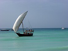
[52][51] They established trade routes with Southern India and Sri Lanka as early as 1500 BCE, ushering an exchange of material culture (like catamarans, outrigger boats, sewn-plank boats, and paan) and cultigens (like coconuts, sandalwood, bananas, sugarcane, cloves, and nutmeg); as well as connecting the material cultures of India and China..[53][54][55][14] They constituted the majority of the Indian Ocean component of the spice trade network.
Indonesians, in particular were trading in spices (mainly cinnamon and cassia) with East Africa using catamaran and outrigger boats and sailing with the help of the Westerlies in the Indian Ocean.
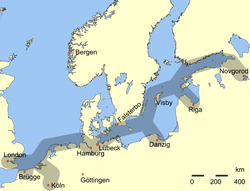
The route began in Scandinavian trading centres such as Birka, Hedeby, and Gotland, crossed the Baltic Sea entered the Gulf of Finland, followed the Neva River into the Lake Ladoga.
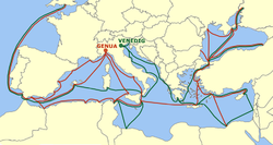
The growing independence of some coastal cities gave them a leading role in this commerce: Maritime Republics, Italian "Repubbliche Marinare" (Venice, Genoa, Amalfi, Pisa, Gaeta, Ancona and Ragusa[75]), developed their own "empires" in the Mediterranean shores.
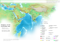
Muslim traders – mainly descendants of Arab sailors from Yemen and Oman – controlled maritime routes throughout the Indian Ocean, tapping source regions in the Far East and shipping for trading emporiums in India, westward to Ormus in Persian Gulf and Jeddah in the Red Sea.
Venetian merchants distributed then the goods through Europe until the rise of the Ottoman Empire, that eventually led to the fall of Constantinople in 1453, barring Europeans from important combined-land-sea routes.
[80] Merchants arriving from India in the port city of Aden paid tribute in form of musk, camphor, ambergris and sandalwood to Ibn Ziyad, the sultan of Yemen.
[81] Indian exports of spices find mention in the works of Ibn Khurdadhbeh (850 CE), al-Ghafiqi (1150), Ishak bin Imaran (907) and Al Kalkashandi (14th century).
[81] On the orders of Manuel I of Portugal, four vessels under the command of navigator Vasco da Gama rounded the Cape of Good Hope, continuing to the eastern coast of Africa to Malindi to sail across the Indian Ocean to Calicut.
[87] Despite its association with China in recent centuries, the Maritime Silk Road was primarily established and operated by Austronesian sailors in Southeast Asia, and by Persian and Arab traders in the Arabian Sea.
[88] The modern times saw development of newer means of transport and often controversial free trade agreements, which altered the political and logistical approach prevalent during the Middle Ages.
[91] A conservative estimate stresses that future damages from harmful animal and plant diseases may be as high as 134 billion US dollars in the absence of effective measures to prevent the introduction of unwanted pests through various trade routes.
[96] According to the Encyclopædia Britannica (2002): Railroads reached their maturity in the early 20th century, as trains carried the bulk of land freight and passenger traffic in the industrialized countries of the world.
Although railroads have lost much of the general-freight-carrying business to semi-trailer trucks, they remain the best means of transporting large volumes of such bulk commodities as coal, grain, chemicals, and ore over long distances.
Automobiles continue to play a crucial role in the economies of the Industrialized countries, resulting in rise of businesses such as motor freight operation and truck transportation.
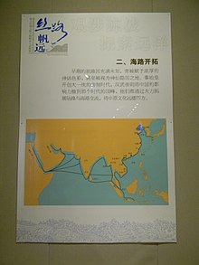
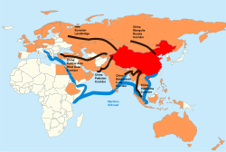
The maritime silk road essentially runs from the Chinese coast to Singapore and Kuala Lumpur, via the Sri Lankan Colombo towards the southern tip of India, to the East African Mombasa, from there to Djibouti, then via the Suez Canal to the Mediterranean, there via Haifa, Istanbul and Athens to the Upper Adriatic region to the northern Italian hub of Trieste with its international free port and its rail connections to Central and Eastern Europe and the North Sea.
In the early 1990s, the nations of the European Union (the successor organization to the Common Market) undertook to remove all barriers to the free movement of trade and employment across their mutual borders."