Typhoon Yuri
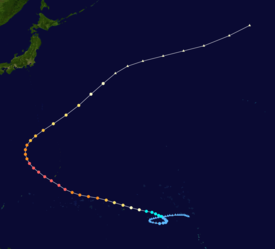
Yuri turned more to the west on 26 November and reached peak intensity the following morning packing winds of over 220 km/h near its centre.
[1] Although Yuri never directly made landfall, it still had managed to cause $3 million (1991 USD) in damage to Pohnpei, including the loss of a radio tower.
In mid-November, the presence of low-level westerlies in the central Pacific provided suitable atmospheric conditions for tropical cyclogenesis.
Yuri later reached typhoon intensity at 1200 UTC on November 24 located roughly 335 km (208 mi) east of Pohnpei while exhibiting an eye.
[3] At 0540 UTC on November 25, Yuri passed 85 km (53 mi) north of Pohnpei with winds of 140 km/h (87 mph).
[3] At 0000 UTC on November 27, the JMA assessed the storm to have reached its peak intensity with 10-minute maximum sustained winds of 220 km/h (140 mph) and a minimum barometric pressure of 895 mbar (895 hPa; 26.4 inHg).
[3] Rounding the western periphery of a subtropical ridge, Yuri began to take a more northerly course, bringing it within 100 km (62 mi) of Guam on November 27 as a strong typhoon.
On the United States territory of Guam, the large yet particularly dangerous and destructive tropical cyclone passed this western Pacific island on November 27.
[6] As civil defense and other workers tried to recover from the 24-foot waves and 115 mph winds of Typhoon Yuri, about three-quarters of Guam remained without electricity on November 28.
Tropical storm (39–73 mph, 63–118 km/h)
Category 1 (74–95 mph, 119–153 km/h)
Category 2 (96–110 mph, 154–177 km/h)
Category 3 (111–129 mph, 178–208 km/h)
Category 4 (130–156 mph, 209–251 km/h)
Category 5 (≥157 mph, ≥252 km/h)
Unknown