Volcanism on Mars
The erupted materials consist of molten rock (lava), hot fragmental debris (tephra or ash), and gases.
Volcanic eruptions produce distinctive landforms, rock types, and terrains that provide a window on the chemical composition, thermal state, and history of a planet's interior.
The degree and extent to which magmas evolve over time is an indication of a planet's level of internal heat and tectonic activity.
The reduced pressure can cause gases (volatiles), such as carbon dioxide and water vapor, to exsolve from the melt into a froth of gas bubbles.
The nucleation of bubbles causes a rapid expansion and cooling of the surrounding melt, producing glassy shards that may erupt explosively as tephra (also called pyroclastics).
The Martian lithosphere does not slide over the upper mantle (asthenosphere) as on Earth, so lava from a stationary hot spot is able to accumulate at one location on the surface for a billion years or longer.
Geologic evidence indicates that most of the mass of Tharsis was in place by the end of the Noachian Period, about 3.7 billion years ago (Gya).
Ceraunius Tholus and Uranius Mons follow the same trend to the northeast, and aprons of young lava flows on the flanks of all three Tharsis Montes are aligned in the same northeast–southwest orientation.
The density of impact craters on many of the tholi indicate they are older than the large shields, having formed between late Noachian and early Hesperian times.
The term was applied to certain ill-defined, scalloped-edged craters that appeared in early spacecraft images to be large volcanic calderas.
In medium resolution images (100 m/pixel), the surface of the volcano has a fine radial texture due to the innumerable flows and leveed lava channels that line its flanks.
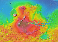
Alba Mons, located in the northern Tharsis region, is a unique volcanic structure, with no counterpart on Earth or elsewhere on Mars.
[32][33][34] Most geological models suggest that Alba Mons is composed of highly fluid basaltic lava flows, but some researchers have identified possible pyroclastic deposits on the volcano's flanks.
The northwestern edge of the province is characterized by large channels (Granicus and Tinjar Valles) that emerge from several grabens on the flanks of Elysium Mons.
[42] Syrtis Major Planum is a vast Hesperian-aged shield volcano located within the albedo feature bearing the same name.
Studies involving the regional gravity field suggest a solidified magma chamber at least 5 km thick lies under the surface.
They may form at the top of a magma chamber after the heavy minerals, such as olivine and pyroxene (those containing iron and magnesium), have settled to the bottom.
[5] Low-relief paterae within the region possess a range of geomorphic features, including structural collapse, effusive volcanism and explosive eruptions, that are similar to terrestrial supervolcanoes.
[47] They are characterized by having extremely low profiles with highly eroded ridges and channels that radiate outward from a degraded, central caldera complex.
Geomorphologic evidence suggests that the highland patera were produced through a combination of lava flows and pyroclastics from the interaction of magma with water.
Some researchers speculate that the location of the highland paterae around Hellas is due to deep-seated fractures caused by the impact that provided conduits for magma to rise to the surface.
Often, when all the remaining lava leaves the tube, the roof collapses to make a channel or line of pit craters (catena).
Ridged plains make up about 30% of the Martian surface[54] and are most prominent in Lunae, Hesperia, and Malea Plana, as well as throughout much of the northern lowlands.
[7] However, the European Space Agency's Mars Express orbiter photographed lava flows interpreted in 2004 to have occurred within the past two million years, suggesting a relatively recent geologic activity.
[58] In 2020, astronomers reported evidence for volcanic activity on Mars as recently as 53,000 years ago in the Cerberus Fossae amid Elysium Planitia.
Some channels in Martian volcanic areas, such as Hrad Vallis near Elysium Mons, may have been similarly carved or modified by lahars.
[64] Finally, when a volcano erupts under an ice sheet, it can form a distinct, mesa-like landform called a tuya or table mountain.
Some researchers[65] cite geomorphic evidence that many of the layered interior deposits in Valles Marineris may be the Martian equivalent of tuyas.
Valles Marineris is a horizontally sliding tectonic boundary that divides two major partial or complete plates of Mars.
So geologists believe the plate is moving while a stationary plume of hot magma rises and punches through the crust to produce volcanic mountains.