Geology of Mars
[10] On 25 October 2023, scientists, helped by information from InSight, reported that the planet Mars has a radioactive magma ocean under its crust.
[11] Mars has a number of distinct, large-scale surface features that indicate the types of geological processes that have operated on the planet over time.
Together, these regions illustrate how geologic processes involving volcanism, tectonism, water, ice, and impacts have shaped the planet on a global scale.
[13] The hemisphere south of the dichotomy boundary (often called the southern highlands or uplands) is very heavily cratered and ancient, characterized by rugged surfaces that date back to the period of heavy bombardment.
In contrast, the lowlands north of the dichotomy boundary have few large craters, are very smooth and flat, and have other features indicating that extensive resurfacing has occurred since the southern highlands formed.
[16] Hypotheses of origin generally fall into two categories: one, the dichotomy was produced by a mega-impact event or several large impacts early in the planet's history (exogenic theories)[17][18][19] or two, the dichotomy was produced by crustal thinning in the northern hemisphere by mantle convection, overturning, or other chemical and thermal processes in the planet's interior (endogenic theories).
Laser altimeters and radar-sounding data from orbiting spacecraft have identified a large number of basin-sized structures previously hidden in visual images.
Called quasi-circular depressions (QCDs), these features likely represent derelict impact craters from the period of heavy bombardment that are now covered by a veneer of younger deposits.
Crater counting studies of QCDs suggest that the underlying surface in the northern hemisphere is at least as old as the oldest exposed crust in the southern highlands.
[29] Averaging 7–10 km above datum (Martian "sea" level), Tharsis contains the highest elevations on the planet and the largest known volcanoes in the Solar System.
The central part of the basin (Hellas Planitia) is 1,800 km in diameter[32] and surrounded by a broad, heavily eroded annular rim structure characterized by closely spaced rugged irregular mountains (massifs), which probably represent uplifted, jostled blocks of old pre-basin crust.
The mountains in the southern portion of the rim, Charitum Montes, may have been eroded by valley glaciers and ice sheets at some point in Mars's history.
Near the equator in the western hemisphere lies an immense system of deep, interconnected canyons and troughs collectively known as the Valles Marineris.
[37] The canyons represent the surface expression of a powerful extensional strain in the Martian crust, probably due to loading from the Tharsis bulge.
The presence of streamlined islands and other geomorphic features indicate that the channels were most likely formed by catastrophic releases of water from aquifers or the melting of subsurface ice.
Another transition occurs at crater diameters of around 130 km as central peaks turn into concentric rings of hills to form multi-ring basins.
[50] Polewards of 30 degrees of latitude, the form of older impact craters is rounded out ("softened") by acceleration of soil creep by ground ice.
Many craters at equatorial and mid-latitudes on Mars have this form of ejecta morphology, which is thought to arise when the impacting object melts ice in the subsurface.
Liquid water in the ejected material forms a muddy slurry that flows along the surface, producing the characteristic lobe shapes.
This sediment has been redeposited in a wide variety of wet environments, including in alluvial fans, meandering channels, deltas, lakes, and perhaps even oceans.
Groundwater has been implicated in the cementation of aeolian sediments and the formation and transport of a wide variety of sedimentary minerals including clays, sulphates and hematite.
Wind driven sand bodies like megaripples and dunes are extremely common on the modern Martian surface, and Opportunity has documented abundant aeolian sandstones on its traverse.
[69] Evidence for ancient rivers,[76] a lake,[77][78] and dune fields[79][80][81] have all been observed in the preserved strata by rovers at Meridiani Planum and Gale crater.
[73][84][85][86][87] Later studies with instruments on board the Mars Reconnaissance Orbiter showed that the same kinds of materials existed in a large area that included Arabia.
[88] On February 19, 2008, images obtained by the HiRISE camera on the Mars Reconnaissance Orbiter showed a spectacular avalanche, in which debris thought to be fine-grained ice, dust, and large blocks fell from a 700-metre (2,300 ft) high cliff.
NASA scientists studying pictures from the Odyssey spacecraft have spotted what might be seven caves on the flanks of the Arsia Mons volcano on Mars.
[92] Recently, a global database (MGC3) of over 1,000 Martian cave candidates at Tharsis Montes has been developed by the USGS Astrogeology Science Center.
The caves may be the only natural structures offering protection from the micrometeoroids, UV radiation, solar flares, and high energy particles that bombard the planet's surface.
[95] These features may enhance preservation of biosignatures over long periods of time and make caves an attractive astrobiology target in the search for evidence of life beyond Earth.
In an article published in 2010, a large group of scientists endorsed the idea of searching for life in Miyamoto Crater because of inverted stream channels and minerals that indicated the past presence of water.


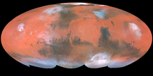
 Clickable image:
Clicking on the labels will open a new article.
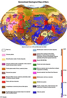
Clickable image:
Clicking on the labels will open a new article.