1921 Tampa Bay hurricane
After entering the Gulf of Mexico, the hurricane gradually curved northeastward and weakened to a Category 3 before making landfall near Tarpon Springs, Florida, late on October 25.
The storm weakened to a Category 1 hurricane while crossing the Florida peninsula, and it reached the Atlantic Ocean early the following day.
Thereafter, the system moved east-southeastward and remained fairly steady in intensity before weakening to a tropical storm late on October 29.
Heavy rains fell in Cuba, particularly in Pinar del Río Province, but only minor damage occurred.
In Florida, storm surge and abnormally high tides caused damage along much of the state's west coast from Pasco County southward.
A number of streets in Tarpon Springs were littered with masses of debris, with many structures and trees suffering extensive damage.
In mid-October, a significant drop in atmospheric pressures over the western Caribbean Sea coincided with the development of a trough on October 17.
Observations suggested that a circulation formed on October 20,[2] with the Atlantic hurricane database listing a tropical storm beginning at 00:00 UTC, with the system was situated about 95 mi (153 km) southeast of the Archipelago of San Andrés, Providencia and Santa Catalina.
[4] Early on October 22, the storm intensified into a Category 1 hurricane, based on sustained winds of 81 mph (130 km/h) on Great Swan Island.
Around 18:00 UTC, the cyclone reached Category 4 intensity and peaked with maximum sustained winds of 140 mph (230 km/h) and a minimum barometric pressure of 941 mbar (27.8 inHg).
[3] Thereafter, the system gradually curved to the northeast as the high pressure weakened and the storm became under the influence of a southwesterly air current.
[5] The storm further weakened to a Category 1 hurricane over Central Florida early on October 26, about six hours before emerging into the Atlantic Ocean near New Smyrna Beach.
[3] These remnants were the second storm encountered by USS Olympia in its Atlantic crossing with the American unknown soldier from World War I.
Additionally, storm warnings were issued eastward from mouth of the Mississippi River and along the east coast of Florida.
[7] In Cuba, heavy rainfall in Pinar del Río Province caused rivers and creeks to rise.
[4] Damage from the wind was generally minor, while most of the impact wrought by the storm was due to abnormally high tides in Tampa and elsewhere in the area.
[16] At Hyde Park, dwellings were inundated about halfway up the first story, prompting several people to be rescued by boat.
Many ships and boats of all sizes capsized or were beached, including the trawler Hypnotist, which ejected the crew of seven into the water, all of whom were rescued.
[21] At the office of the St. Petersburg Times, then located at Fifth Street and First Avenue South, the loss of electricity resulted in staff working overnight with lanterns.
Two deaths occurred in St. Petersburg, one from a heart attack during preparations for the storm and the other from a man being crushed by a falling roof.
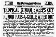
[20] Initially, there were rumors and unconfirmed reports that Pass-a-Grille (today a neighborhood of St. Pete Beach) was wiped out and that up to 150 deaths occurred.
[23] Storm surge was partially diverted to Boca Ciega Bay,[24] but Pass-a-Grille generally suffered severe impact due to 5 to 7 ft (1.5 to 2.1 m) of water covering some areas.
The Sunnybrook Tobacco Company suffered significant impact, with nine large barns destroyed and about 110 acres (45 ha) of trees toppled.
[37] In Polk County, the storm left light property damage in Lakeland, reaching under $5,000,[10] which included the school building being deroofed.
Additionally, it is possible that a tornado touched down, based on some pine trees being "splintered from top to bottom and curled up like molasses candy.
[35] Local officials, businessmen, realtors, and later the press soon attempted to cover up or downplay the damage, which threatened to distort Tampa's advertised image as the "Year Round City".
In the past few decades especially, local officials have been concerned about a major hurricane impacting the area due to population increases, older building codes, storm surge projections, and complacency among some residents.
The combined population of Citrus, Hernando, Hillsborough, Pasco, and Pinellas counties has increased from about 135,000 people in 1921 to approximately 2.7 million by 2011.
[46] In Pasco County, more than half of the homes were constructed prior to the enactment of stronger building codes in the aftermath of Hurricane Andrew.
Another property firm, Karen Clark & Co., estimated in 2015 that storm surge could inflict as much as $175 billion (2015 USD) in damage in a worst-case scenario.

Tropical storm (39–73 mph, 63–118 km/h)
Category 1 (74–95 mph, 119–153 km/h)
Category 2 (96–110 mph, 154–177 km/h)
Category 3 (111–129 mph, 178–208 km/h)
Category 4 (130–156 mph, 209–251 km/h)
Category 5 (≥157 mph, ≥252 km/h)
Unknown