1945 Texas hurricane
In favorable conditions, the system quickly intensified as it steadily moved northward, attaining hurricane intensity later that day.
Upon making landfall, the storm brought strong winds, which caused widespread power outages and infrastructural damage.
Port Lavaca, Texas was inundated by a 15 ft (4.6 m) storm surge, which at the time was the third highest ever recorded in the state.
Towards the end of August 1945, an area of squally weather persisted in the Bay of Campeche, near the Gulf Coast of Mexico.
After a prolonged period of marginal development, the cluster of thunderstorms began to quickly organize beginning on August 24.
Initially, the tropical storm moved generally northward at approximately 18 mph (29 km/h), but gradually slowed as it neared the United States Gulf Coast.
Quickly developing past tropical cyclogenesis, the system reached the equivalent of a modern-day Category 1 hurricane at 0600 UTC on August 25.
[3] Its forward motion continued to slow until it moved nearly stationary at roughly 5 mph (8.0 km/h), which allowed the system to remain a tropical cyclone for an extended period of time, despite its proximity to the coast.
[3] The hurricane executed a slight curve to the northeast later that day, causing it to move inland over the Texas coast.
[2][3] However, a reanalysis was conducted on the system, and concluded that it had only attained Category 3 intensity before making landfall at 1200 UTC that day.
[3] At the time, the storm had maximum sustained winds confined within an area about 10 miles (16 km) from the hurricane's center.
[5] However, all small craft offshore from the mouth of the Rio Grande and Burrwood, Louisiana were warned to remain in port or return to the coast.
[10] Throughout the hurricane's early developmental stages, reconnaissance flights were periodically made into the storm to gather data.
[11] Though situated on the opposite side of the Gulf of Mexico as Florida, tropical moisture extending from the hurricane caused torrential rainfall in the state.
Telecommunications in the Tampa Bay Area were delayed for up to two hours due to damage sustained to communication lines as a result of the rains.
Despite its nearby proximity, effects in Tampa, Florida were much less severe, with only small showers and gusts never exceeding 25 mph (40 km/h).
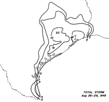
[13] The hurricane's slow movement parallel to the Texas coast resulted in torrential rainfall, peaking at 19.6 in (500 mm) near Hockley over a period of a little over three days.
[21] In Houston, the heavy rains halted traffic and increased flood risk to property near the city's bayous.
[2] After the hurricane passed, the American Red Cross and other relief agencies began to survey damage and assist in repair and rehabilitation activities.
Robert Edison, then-director of the Midwest sector of the agency, requested 5,000,000 ft (1,500,000 m) of lumber and 52 tons (47 tonnes) of steel.

Tropical storm (39–73 mph, 63–118 km/h)
Category 1 (74–95 mph, 119–153 km/h)
Category 2 (96–110 mph, 154–177 km/h)
Category 3 (111–129 mph, 178–208 km/h)
Category 4 (130–156 mph, 209–251 km/h)
Category 5 (≥157 mph, ≥252 km/h)
Unknown