2011 Super Outbreak
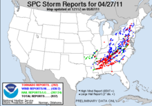
[9] In total, 348 people were killed as a result of the outbreak, including 324 tornado-related deaths across six states and 24 fatalities caused by other thunderstorm-related events such as straight-line winds, hail, flash flooding or lightning.
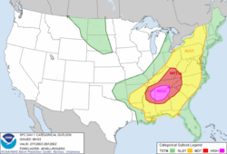
[20] Conditions were similar on April 26, with a predicted likelihood of severe thunderstorms, including an extended threat of strong to violent long-track tornadoes throughout the afternoon and evening hours; mixed-layer CAPE values were forecast to be around 3000–4000 J/kg, around east Texas, Louisiana, and Arkansas.
The storm mode on April 26 was predicted to include mostly discrete tornadic supercells during both the afternoon and the early evening, shifting over to a mesoscale convective complex, with more of a threat of damaging winds and hail during the nighttime hours.
Tornado watches were issued for the Lower Great Lakes during the afternoon hours as supercell thunderstorms developed along the warm front lifting north across central Michigan.
[36] An isolated supercell moved across Central New York throughout much of the afternoon, producing golf ball-sized hail in Syracuse and spawning a very brief EF1 tornado in Verona Mills, which primarily caused damage to trees.
As the low formed across Texas and deepened while moving east, a tightening pressure gradient force further strengthened the low-level jet, therefore creating a broad warm sector across the southeastern states.
Later that morning, the SPC even increased the probability for tornadoes to 45 percent along a corridor from Meridian, Mississippi, to Huntsville, Alabama, an extremely rare issuance exceeding the high risk standards.
[40] During the early morning hours, a cold front with several embedded low pressure areas extended from east Texas northeastward into the Ohio River Valley.
Early in the morning the squall line, packing straight-line winds and numerous embedded tornadoes, moved through Louisiana and Mississippi before proceeding to affect North and Central Alabama and parts of Middle and East Tennessee.
[42] As the line entered Cullman County, Alabama, the cell, a mesoscale convective vortex (MCV), began exhibiting a comma head appearance and produced another long-tracked EF2 tornado that struck the town of Hanceville, killing one person.
[41] From the late morning to the early afternoon, another squall line moved through northern parts of Mississippi and Alabama as high wind shear and low-level moisture persisted.
However, this time several discrete supercells developed along and in front of the line, spawning seven weak tornadoes across Morgan, Limestone, and Madison Counties in northern Alabama around noon that day.
The same supercell produced another EF4 tornado later that evening that killed 22 people and struck the Ohatchee, Alabama, area and eventually crossed into Georgia, causing additional damage near Cave Spring before dissipating.
[52][53] A very large EF4 wedge tornado leveled a mile-wide swath of forest through 14 miles (23 km) of Great Smoky Mountains National Park, resulting in many trails being closed.
[56] A secondary area of severe weather also developed that afternoon and evening along a corridor extending from central and northern Virginia northward through Maryland, Pennsylvania, and New York, continuing into early April 28.
The EF5 tornado that struck Hackleburg and Phil Campbell damaged main high-transmission power lines coming from Browns Ferry Nuclear Plant near Tanner.
The tornado reached EF2 strength as it crossed into Faulkner County and passed southeast of Mayflower, downing numerous trees and power lines and damaging homes and outbuildings.
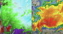
The ABC 33/40 camera captured the destruction of a communications tower belonging to Cullman area low-power television station WCQT-LP as the tornado ripped through the city at EF3 intensity.
[95] The tornado then briefly passed through a section of Morgan County near the town of Hulaco, destroying several older block-foundation homes and snapping numerous large trees off at the base.
As the storm crossed into Madison County, it approached the densely populated suburban communities of Harvest and Toney, where it either damaged or destroyed hundreds of homes, especially in the Anderson Hills and Carter's Gin subdivisions.
On the southeast side of Blountsville, the tornado downed many trees and caused high-end EF2 damage to well-built brick and slab foundation homes, one of which had some exterior walls collapse.
[106][108] This violent EF5 wedge tornado, with estimated winds of up to 205 mph (330 km/h), struck the town of Smithville, Mississippi, at 3:47 p.m. CDT (20:47 UTC) on April 27, resulting in catastrophic damage and numerous fatalities.
Thousands of trees were snapped, a log cabin was destroyed, livestock was killed, chicken houses were flattened, and a van was lofted and dropped into a field 400 yards (370 m) away from where it originated.
[130][131][132][133] This extremely long-tracked, violent EF4 tornado touched down near Raleigh, Mississippi, in Smith County at 5:42 p.m. CDT (22:42 UTC), and continued into the Uniontown, Alabama, area before dissipating.
[134][135][136] This violent multiple-vortex tornado that originated from the Cordova supercell, rated EF5, began in the Lakeview community northeast of Geraldine, Alabama, at 6:19 p.m. CDT (23:19 UTC), during the late afternoon of April 27.
Past Fyffe, the tornado became violent, and its width increased from around 50 yards (46 m) to 0.5 miles (800 m) as it entered eastern Rainsville, reaching EF5 intensity as it destroyed numerous homes and businesses.
[148][149] The tornado then crossed into Bradley County at low-end EF4 strength, moving across the southern and eastern fringes of Cleveland and affecting mainly residential areas, though a few businesses were damaged or destroyed as well.
It began to track just east of due north along Grier Road (CR 209) at high-end EF1 intensity, snapping trees and blowing out the south facing gable-end of the roof of a home.
Trees were snapped or uprooted along this final portion of the path before the tornado dissipated at 9:09 p.m. CDT (02:09 UTC) after tracking 44.18 miles (71.10 km) and reaching a maximum width of 880 yards (800 m).
[193] In addition to traffic and safety issues, the outage caused difficulties with water treatment and distribution and retail of all kinds, including gasoline and food purchases.