November 2020 North American storm complex
The system originated from a weak gulf low off the coast of Texas on November 29, which began to move northeastward onto land the next day.
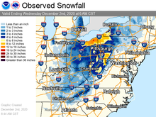
It then began to strengthen, as well as slowing its movement down, resulting in heavy, wind-driven snow for prolonged periods of time in the Ohio Valley.
It also triggered a major lake-effect snow event from December 1–2 as the system stalled over Lake Ontario, resulting in additional heavy snowfall.
[5] The system reached a peak intensity of 993 millibars (29.3 inHg) at 00:00 UTC on December 1, while two of the low-pressure areas dissipated and the main low stalled out over Lake Ontario.
[9] Winter Storm Warnings were issued in parts of Ohio and Pennsylvania, mainly along the shores of Lake Erie due to the potential for heavy snow.
[2] A fairly large area of Ohio and Pennsylvania picked up over 10 inches (25 cm) of snow, with the highest totals near Lake Erie.