Adams County, Pennsylvania
This county seat community is surrounded on three sides by the Gettysburg National Military Park (GNMP).
The Eisenhower National Historic Site adjoins GNMP on its southwestern edge.
Most of Adams County's rural landscapes and its mid-19th century roadway pattern remain intact today.
This "spokes and wheel" pattern is one of the few examples of Central Place Theory in the Eastern United States.
The county is in the watershed of the Chesapeake Bay and is drained by the Susquehanna and Potomac Rivers.
As of the May 2024[6] Presidential politics Adams is a consistently Republican county, like most of South Central Pennsylvania.
[7] No Democratic presidential candidate has won Adams County since Lyndon Johnson's 1964 landslide.
90.7% of the population 25 years and over were high school graduates, and 24.3% had a bachelor's degree or higher.
The racial makeup of the county was 87% White, 1% Black or African American, 0.0% Native American, 1% Asian, 0.0% Pacific Islander, 3% from other races, and 7% of the population were Hispanic or Latino of any race.
The US OMB[21] has designated Adams County as the Gettysburg, PA metropolitan statistical area (MSA).
[24] As reported by Pennsylvania Department of Education May 2024 Lincoln Intermediate Unit (IU#12) region includes Adams, Franklin, and York counties.
It runs Summer Academy, which offers both art and academic strands designed to meet the needs of gifted, talented and high achieving students.
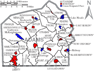
Under Pennsylvania law, there are four types of incorporated municipalities: cities, boroughs, townships, and, in at most two cases, towns.
The following boroughs and townships are located in Adams County, as well as unincorporated areas and CDPs: Census-designated places are geographical areas designated by the U.S. Census Bureau for the purposes of compiling demographic data, but are not actual jurisdictions under Pennsylvania law.