Air mass
Air masses cover many hundreds or thousands of square miles, and adapt to the characteristics of the surface below them.
Weather fronts separate air masses with different density (temperature or moisture) characteristics.
Once an air mass moves away from its source region, underlying vegetation and water bodies can quickly modify its character.
For instance, an air mass originating over the desert southwest of the United States in summer may be designated "cT".
[3] An example of this might be a polar air mass blowing over the Gulf Stream, denoted as "cPk".
For instance, an Arctic air mass blowing out over the Gulf of Alaska may be shown as "cA-mPk".
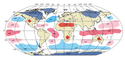
[4] Tropical and equatorial air masses are hot as they develop over lower latitudes.
Continental polar air masses that affect North America form over interior Canada.
Other less important sources producing cT air masses are the Arabian Peninsula, the central arid/semi-arid part of Australia and deserts lying in the Southwestern United States.
[9] A weather front is a boundary separating two masses of air of different densities, and is the principal cause of meteorological phenomena.
Surface flux from underlying vegetation, such as forest, acts to moisten the overlying air mass.
[15] Because of this temperature difference, warmth and moisture are transported upward, condensing into vertically oriented clouds (see satellite picture) which produce snow showers.