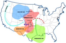
Dry line
It typically lies north-south across the High Plains states in the warm sector of an extratropical cyclone and stretches into the Canadian Prairies during the spring and early summer.
[citation needed] The dry line is also important for severe convective storms in other regions of the world, such as northern India and Southern Africa.
A dry punch aloft above an area of warm, moist (buoyant) air at low levels often increases the potential for severe thunderstorms.
Stronger dry line passages result in a sharp drop in dew point, clearing skies, and a wind shift from south or south-easterly to west or south-westerly.
Severe and sometimes tornadic thunderstorms often develop along the slope-reversal zone east of the surface dry line, especially when it begins moving eastward.
[12] The moist sector is normally capped with a lid of an elevated mixed drier layer which represents subsidence from aloft as the surface air cools and contracts at night.