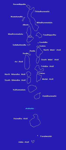
Atolls of the Maldives
In 1834–1836, British captain Robert Moresby undertook the laborious and difficult cartography of the Maldives, drawing the first accurate maritime charts of this complicated Indian Ocean atoll group.
Although they contain a few errors, Moresby's charts were so good that they were favoured by Maldivian pilots navigating through the treacherous waters of their atolls until the 1990s.
However, Maldivian navigators still claim that Captain Moresby's charts provide a wealth of data that the modern maps do not give.
Owing to the many beautiful diving grounds of the numerous atolls of the Maldives, this country has been marketed as a prime destination for scuba divers worldwide.
Hence, during the last couple of decades many guides and maps of the best diving spots have been published and some of them are very accurate and give a wide array of useful hints.
The list below are the names of the geographical or natural atolls and single islands of the Maldives archipelago, going from north to south, together with a brief description.
It is a huge atoll stretching SSW for 76 kilometres (47 miles) and contains nearly forty islands generally of a fair size.
The western boundary has fewer islands but more isolated reefs or micro-atolls (called faru in Maldivian), with wide passages between them.
The German explorer Hans Hass observed the formation of this phenomenon called "micro-atoll" by Porites corals in the Maldives.
Along its western edges there are not many islands but more detached reefs with shallow lagoons (called vilu in Maldivian) which seldom exceed 10 fathoms (18 m) in depth.
Its western fringe is composed of a series of round or oval reefs (farus) irregularly placed (a feature peculiar to all the larger Northern Atolls).
In places its lagoon contains small reef-patches, but it is generally dotted with many large coral reefs, some of which remain submerged even at low tide.
Felidhe Atoll has a very irregular outline; it is surrounded by continuous barrier reefs, or by small patches with vilu separated by narrow passages.
The lagoon is comparatively open, with few, but relatively greater farus as well as a few small coral patches or shoals (giri); average depth 27 to 35 fathoms (49 to 64 m), muddy bottom.
The lagoon is comparatively open, although it is studded with numerous small coral patches or shoals which are awash at low tide.
Its reefs are generally of little breadth, with no signs of vilu, except for its eastern fringes which are covered with islands that are quite large by Maldive standards.
The lagoon is comparatively open, containing scattered shoal patches and no emerged islands; the bottom is muddy and the average depth is from 30 to 34 fathoms (55 to 62 m).
[4] Fuvahmulah ('Fua Mulaku' in the Admiralty Chart) is a large single island (by itself a small detached atoll) which lies in the Equatorial Channel.
In the distant past Fuvahmulah was a small coral atoll whose southern end was open at a spot called Diyarehifaando and the inside of the island was a saltwater lagoon forming a natural harbour.
There is a spot in the southern end known as a Kudhuheraivali (the forest of the small islet), which indicates that there was a separate little island in that area in ancient times.
In time the inner lagoon lost its saltiness and all that remains today are two small lakes, wetlands and marshy taro fields.
Addu Atoll is 21 kilometres (13 miles) long and it is fringed by broad barrier reefs with large islands on its eastern and western sides.
Its lagoon has no islands and is relatively open with few shoals in its centre, but having mazes of coral patches close to the NW and NE corners of its encircling reefs in 7 to 10 fathoms (13 to 18 m) of water.
Note: Further south Haddhummati in the middle of the vast emptiness of the Huvadu Channel there is a small bank known as Medutila (also called Derahaa).
These were important for ancient mariners plying along the spice route trying to bypass the long atoll chains without harm.
New islands also may appear, beginning as sandbanks or coral gravel heaps at another location of the reef (a phenomenon that is known among Maldivians as hikemun dhiyun).
The Maldive atolls are part of the long submerged mountain range that extends from the Laccadives, or Lakshadweep, in the north, to the Chagos in the south.
But even in these remote and strongly oceanic Southern Maldive atolls, knowledge about their neighboring island group is only vague and fragmentary.
The earliest mention of all the names of the atolls of the Maldives is in describing the Deeva Mahal Kingdom of King Koimala Siri Mahaabarana around 1117 A.D.
With this book, the late Mr. Luthfee tried to clear a number of misconceptions that carelessly researched tourist publications have generalized even among Maldivians.