Geography of Afghanistan
With a location at the intersection of major trade routes, Afghanistan has attracted a succession of invaders since the sixth century BCE.
There are a number of major rivers in the country, including Amu Darya, Arghandab, Farah, Hari, Helmand, Kabul, Kokcha, and Kunar.
[26][27][28][29] Afghans argue that an exclusive classification of their countries as South Asian could be misinterpreted as an implicit validation of such expansionist ideologies, threatening the national and cultural identity of their homeland.
As a result, they contend thatAfghanistan's connections to Central Asia and the Middle East must be acknowledged and emphasized to counter any expansionist narratives that challenge the country's sovereignty.
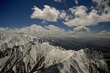
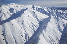
[citation needed] The Hindu Kush mountain range reaches a height of 7,492 m (24,580 ft) at Noshaq, Afghanistan's highest peak.
The summit of the Khyber Pass at 1,070 m (3,510 ft) at Landi Kotal, Pakistan is 5 km (3 mi) east of the border town of Torkham.
The Wakhan Corridor in the northeast lies eastward of the province of Panjshir, between the Hindu Kush and the Pamir Mountains, which leads to the Wakhjir Pass into Xinjiang in China.
Yet, it was not very far from Herat, in Rafir Kala, in 1750, where Ahmad Shah's army, retreating from Persia, is said to have lost 18,000 men from cold in a single night.
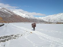
The eastern reaches of the Hari River, including the rapids, are frozen hard in the winter, and people travel on it as on a road.
The sun shines for three-fourths of the year, and the nights are clearer than the days.Taking the highlands of the country as a whole, there is no great difference between the mean temperature of Afghanistan and that of the lower Himalaya.
[citation needed] On the other hand, the summer temperature is exceedingly high, especially in the Oxus regions, where a shade maximum of 45–50 °C (113–122 °F) is not uncommon.
[31] The summer rains that accompany the southwest monsoon in India, beat along the southern slopes of the Himalaya, and travel up the Kabul valley as far as Laghman, though they are more clearly felt in Bajour and Panjkora, under the Hindu Kush, and in the eastern branches of Safed Koh.
The great mass of it is confined to the main ranges and their immediate offshoots, whilst on the more distant and terminal prolongations it is almost entirely absent; in fact, these are naked rock and stone.
On the Safed Koh alpine range itself and its immediate branches, at a height of 1,800–3,000 m (5,900–9,800 ft) there is abundant growth of large forest trees, among which conifers are the most noble and prominent, such as Cedrus deodara, Abies excelsa, Pinus longifolia, Pinus pinaster, Stone pine (the edible pine, although this species is probably introduced, since it is original to Spain and Portugal) and the larch.
Growing under the shade of these are several varieties of rose, honeysuckle, currant, gooseberry, hawthorn, rhododendron and a luxuriant herbage, among which the ranunculus family is important for frequency and number of genera.
The walnut and oak (evergreen, holly-leaved and kermes) descend to the secondary heights, where they become mixed with alder, ash, khinjak, Arbor-vitae, juniper, with species of Astragalus.
In some places, occupying the sides and hollows of ravines, it is found the Rose Bay, called in Persian khar-zarah, or ass-bane, the wild laburnum and various Indigoferae.
On the positive note, the Karzai administration and international organizations are helping counter this problem by often planting millions of saplings.