Azawad
Azawad borders Burkina Faso to the south, Mauritania to the west and northwest, Algeria to the north and northeast, and Niger to the east and southeast, with undisputed Mali to its southwest.
[5] The proclamation was never recognised by any foreign entity,[6] and the MNLA's claim to have de facto control of the Azawad region was disputed by both the Malian government and Islamist insurgent groups in the Sahara.
[7] The Economic Community of West African States, which refused to recognise Azawad and called the declaration of its independence "null and void", warned it could send troops into the disputed region in support of the Malian claim.
[8][9] Tuareg military leader Moussa Ag Acharatoumane, affiliated with the Movement for the Salvation of Azawad (French: Movement pour le Salut de l'Azawad), was interviewed by the French language news outlet TV5Monde, during its "Le journal Afrique" or "African Journal" segment, about hostile events that occurred between the MNLA and other separatist groups against jihadi extremists in 2012.
[10][11] He claimed that jihadi groups, and the Ansar Dine in particular, had been in the region of Azawad for 10 years before the circumstances which led to the Azawadi declaration of independence.
Ag Acharatoumane further asserted that the death of Muammar Gaddafi destabilised the political landscape for Sahelians from Mali and Niger to such a degree that it was described as "disastrous."
[12][13] On 14 February 2013, the MNLA renounced its claim of independence for Azawad and asked the Malian government to start negotiations on its future status.
[14] The MNLA ended the ceasefire in September of the same year after government forces reportedly opened fire on unarmed protesters.
[15][16] According to the Scottish explorer and scientist Robert Brown, Azawad is an Arabic corruption of the Berber word Azawagh, referring to a dry river basin that covers western Niger, northeastern Mali, and southern Algeria.
Askia Mohammad I created a golden age for both the Songhay Empire and Timbuktu through an efficient central and regional administration that allowed sufficient leeway for the city's commercial centers to flourish.
Searching for gold, he led an expedition of 4,000 Andalusian Moriscos, 500 mercenaries and 2,500 auxiliaries, including slaves, dubbed the Arma.
Sources conflict on who was in control when the French colonizers arrived: a 1924 article in the Journal of the Royal African Society mentions the Tuareg,[40] the historian Elias N. Saad in 1983 suggests the Soninke Wangara,[38] while the Africanist John Hunwick wrote in 2003 that several states competed for power 'in a shadowy way' until 1893.
[41] After European powers formalized the scramble for Africa in the Berlin Conference, the French assumed control of the land between the 14th meridian and Miltou, South-West Chad, bounded in the south by a line running from Say, Niger to Baroua.
On 15 December 1893, Timbuktu, by then long past its prime, was annexed by a small group of French soldiers, led by Lieutenant Gaston Boiteux.
[45] On 17 January 2012, the MNLA announced the start of an insurrection in Northern Mali against central government, declaring that it "will continue so long as Bamako does not recognise this territory as a separate entity".
[46] After the first attack took place in the town of Ménaka, further fighting was reported in different parts of the north, including Aguelhok, Tessalit, Léré, and Niafunké.
[47] On 24 January, the MNLA won control of the town of Aguelhok, killing around 160 Malian soldiers and capturing dozens of heavy weapons and military vehicles.
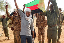
In a statement released on the occasion, the MNLA invited all Tuaregs abroad to return home and join in constructing institutions in the new state.
The French Foreign Ministry said it would not recognise the unilateral partition of Mali, but it called for negotiations between the two entities to address "the demands of the northern Tuareg population [which] are old and for too long had not received adequate and necessary responses".
[61] In December 2012, the MNLA agreed on Mali's national unity and territorial integrity in talks with both the central government and Ansar Dine.
The MNLA co-operated with the French troops, providing guides and logistical services and renting space in their military bases.
[63] However, Mali's President Ibrahim Boubacar Keita shelved the plans for the referendum on constitutional reforms that were met with opposition and ignited regular street protests.
Reuters wrote of the terrain: "Much of the land is the Sahara desert at its most inhospitable: rock, sand dunes and dust scored by shifting tracks.
The most important of these paleochannels is the Wadi el-Ahmar, which is 1 200 metres wide at its southern end, at the Niger bend, and winds 70 to 100 kilometres northward.
It included:[70] Although the MNLA claimed responsibility for managing the country "until the appointment of a national authority" in their declaration of independence, it has acknowledged the presence of rival armed groups in the region, including Islamist fighters under Ansar Dine, the Movement for Oneness and Jihad in West Africa, and Al Qaeda in the Islamic Maghreb (AQIM).
[73] At a conference, the Azawadis voiced their disapproval of radical Islamic groups, and asked all foreign fighters to disarm and leave the country.
The peoples who constitute a major share of the population of northern Mali, such as Songhai and Fulani, considered themselves to be Malian and had no interest in a separate Tuareg-dominated state.
[citation needed] Most popular in the Tuareg movement and northern Mali as a whole is the Maliki branch of Sunnism, in which traditional opinions and analogical reasoning by later Muslim scholars are often used instead of a strict reliance on hadith as a basis for legal judgment.
They strongly object to praying around the graves of Malikite 'holymen', and burned down an ancient Sufi shrine in Timbuktu, which had been listed as a UNESCO World Heritage Site.
[88] The people living in the central and northern Sahelian and Sahelo-Saharan areas of Mali are the country's poorest, according to an International Fund for Agricultural Development report.


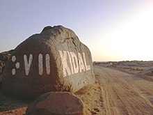
(left side in Tifinagh : "kdl")