Beaver County, Pennsylvania
[8] It has a humid continental climate (Dfa/Dfb) and average monthly temperatures in the Beaver/Rochester vicinity range from 29.4 °F in January to 73.2 °F in July.
[9] Beaver County is one of the 423 counties served by the Appalachian Regional Commission,[10] and it is identified as part of the "Midlands" by Colin Woodard in his book American Nations: A History of the Eleven Rival Regional Cultures of North America.
23.0% were of German, 17.4% Italian, 9.9% Irish, 6.5% English, 6.4% Polish and 5.8% American ancestry.
Of all households 26.90% were made up of individuals, and 13.10% had someone living alone who was 65 years of age or older.
In 2004, Democrat John Kerry won Beaver County over Republican George W. Bush 51% to 48%.
Mitt Romney and Donald Trump (twice) carried the county in the next three elections.
In 2010, Republican Governor Tom Corbett and Republican Senator Pat Toomey both carried Beaver in their successful statewide bids, and Toomey won the county again in 2016.
The North Country National Scenic Trail (NCT) passes through the county's northern end.
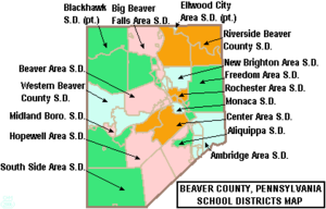
[32] Beaver County Transit Authority As reported by the Pennsylvania Department of Education – EdNA, as of April 2010.
Under Pennsylvania law, there are four types of incorporated municipalities: cities, boroughs, townships, and, in at most two cases, towns.

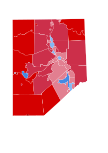
Biden: 50–60% 60–70%
Trump: 50–60% 60–70% 70–80% 80–90%