Mangrove tree distribution
The area covered by mangroves is influenced by a complex interaction between land position, rainfall hydrology, sea level, sedimentation, subsidence, storms and pest-predator relationships[2][3]).
Mangroves provide several important ecological services including coastal stabilization, juvenile fish habitats, and the filtration of sediment and nutrients[4][5][6]).
[13] Along the coast of the Red Sea, both on the Egyptian side and in the Gulf of Aqaba, mangroves composed primarily of Avicennia marina and Rhizophora mucronata[14] grow in about 28 stands that cover about 5.25 km2 (2.0 sq mi).
[17] Mangroves occur on the Pacific and Caribbean coasts of Belize, Costa Rica, El Salvador, Guatemala, Honduras, Nicaragua, and Panama.
[26] In Mexico, four species of mangrove predominate: Rhizophora mangle, Laguncularia racemosa, Avicennia germinans, and Conocarpus erectus.
[29] The northern portion of Esmeraldas province has a large pristine mangrove forest that is preserved as the Reserva Ecológica Cayapas-Mataje (REMACAN) and is an original Ramsar site.
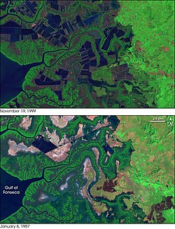
[1] Venezuela's northern Caribbean island, Margarita, possesses mangrove forests in the Parque nacional Laguna de La Restinga.
Between 1968 and 1983, 2,370 km2 (920 sq mi) of mangrove forest were lost to the creation of cultured ponds for farming fish, shrimp, and other aquatic resources.
[46][47][48] Due to conservation measures it rose back to the current level by 2003 and mangrove populations are considered "relatively stable" by the World Bank.
[50] Taxonomic identification revealed eleven mangrove species – Avicennia marina, Avicennia rumphiana, Bruguiera gymnorrhiza, Ceriops decandra, Ceriops tagal, Excoecaria agallocha, Rhizophora apiculata, Rhizophora mucronata, Sonneratia alba, Xylocarpus granatum, and Xylocarpus moluccensis belonging to five families.
The ban also affects small communities which previously partnered with the government to grow and harvest mangrove forests for timber, firewood, and other purposes.
[54] Sungei Buloh Wetland Reserve, Pasir Ris Park and Chek Jawa are some areas with publicly accessible walking trails within mangrove forests.
The mangrove forests of the Bay of Kompong Som (maki) in Cambodia are of major ecological and cultural importance, as the human population relies heavily on the crabs and fish that live in the roots.
The wide and shallow shelf on Yemen's Red Sea coast consists of unconsolidated sediments, which support 11 species of seagrasses up to 500 m (1,600 ft) offshore on the shoreward side of sand spits, islands and reefs.
Forests on and near the island of Qeshm in the Persian Gulf are dominated by the species Avicennia marina, known locally as the "hara" or "harra" tree, and cover an area of approximately 20 km2 (7.7 sq mi).
This area is protected as the UNESCO Hara Biosphere Reserve, where commercial use is restricted to fishing (mainly shrimp), tourist boat trips, and limited mangrove cutting for animal feed.
Additionally, the Sundarbans serves a crucial function as a protective flood barrier for the millions of inhabitants in and around Kolkata against the result of cyclone activity.
[4][88][89] Different data sources or survey methods make estimates more problematic, as many nations have high variations of mangrove change.
The declining rate of mangrove loss since 2000 across all regions is indicative of this, bringing forth an increasing number of conservation projects and legislation.
Where tourism is a main contributor to an economy (such as Pacific Island nations), construction of resorts and related infrastructures have reduced mangrove area in past decades.
Compounding mangrove losses is the short life span of individual ponds (5–10 years), imposing a shifting cultivation pattern to shrimp farming.
[90] For example, loss of income for local Thai fishermen has been reported due to reduced catches from the degradation of juvenile fish habitat.
[98] Climate change may reduce global mangrove area by 10–15%, but it is a long term, less significance threat to the current 1–2% annual loss from human activities.
Seaward mangrove expansion is considered a natural response to high inputs of sediment and nutrients from human activity in adjacent catchments;.
In New Zealand (NZ), temperate mangroves (Avicennia marina) are common in estuaries, harbours and tidal creeks north of 38° latitude.
[89] For example, Bangladesh has undertaken extensive coastal afforestation (mass plantings) projects since 1966, leading to an increase in mangrove area in recent decades;[89][105] 2005;.
For instance, community initiatives to protect mangroves are common in Africa but little legislation exists compared to other regions, such as Asia.
Average lowest temperatures have been increasing due to climate change, and this trend allows the survival of propagules during winter and germinate in warmer seasons.
In New South Wales in Australia, area coverage of salt marsh has declined due to poleward expansion of mangrove species.
Recently the rate of loss has been declining due to a greater awareness of mangrove values, with legislation and conservation projects becoming more commonplace.