1893 Cheniere Caminada hurricane
Another assessment of the storm published in 2014 suggested that the hurricane may have originated in the Bay of Campeche, avoiding the Yucatan Peninsula entirely.
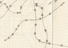
The storm then made landfall on October 2 as a slightly weaker hurricane with maximum sustained winds of 110 mph (175 km/h) near Ocean Springs, Mississippi.
It weakened inland over the Southeastern U.S. and continued to decay after entering the open Atlantic at Cape Hatteras, after which it dissipated around October 5.
In the same article, the Weather Bureau speculated that the storm could have originated closer to Mexico or Honduras from a long trough of low pressure, but also noted that the contemporaneous wind observations along the Gulf Coast could lend credence to a sudden emergence of the hurricane in the gulf as late as the morning of October 1.
[3] In the official Atlantic hurricane database sanctioned by the World Meteorological Organization, the storm is listed as beginning on September 27 in the western Caribbean Sea northeast of the border between Nicaragua and Honduras.
Tracking towards the northwest, the storm then traversed the northeastern parts of the Yucatan Peninsula and weakened slightly before moving into the Gulf of Mexico, where it restrengthened and curved towards the north and later northeast.
[3] The Weather Bureau had been unaware of the storm, predicting southeasterly winds and fair conditions following "light showers" on the Gulf coast for the night of October 1.
[6] In reviewing and revising the tracks of historical storms maintained by the National Climatic Center, meteorologist José Fernández-Partagás found that the storm's listed positions prior to October 1 could not be reviewed due to a "lack of suitable information" and made no changes to the preexisting track in the database.
[5][10][11] Weather instruments in the path of the storm were all blown down or destroyed, leaving no surviving complete record of the winds and rain associated with the landfalling hurricane.
The hurricane was likely small upon making landfall, with the estimated 14 mi (23 km) radius of maximum wind being smaller than the average Atlantic storm at a similar intensity and latitude.
[10] Most of the deaths occurred in southeastern Louisiana, particularly around the Mississippi River Delta and in Plaquemines Parish; the Weather Bureau reported that over 1,500 of those fatalities were the result of drowning.
[13][14] The swath of coastal damage spanned 500 mi (800 km), extending from Louisiana's Timbalier Bay eastward to Pensacola, Florida.
[7] Though instrumentation in the storm's path failed to withstand the intense conditions,[3] observers in southeastern Louisiana estimated winds exceeding 100 mph (160 km/h) at Pointe à la Hache and on the Chandeleur Islands.
[17] There was one avenue of safety, and that was to seek the upper stories of the houses, but even that chance for escape was lost, when the wind and waves combined shook the frail habitations, which rocked to and fro and creaked and groaned under the repeated attacks of the furious elements.
Above the thundering voice of the hurricane could be heard the despairing cries, the groans and the frantic appeals for help of the unfortunate victims.Grand Isle was also heavily impacted; 27 people were killed there.
[8] Significant damage also occurred in the towns of Doullut, Grand Prairie, Home Place, Neptune, Ostrica, Point Pleasant, and Venice.
[10] The storm's effects in New Orleans were first felt at 6:30 p.m. CT on the evening of October 1 and lasted through the overnight hours, resulting in flooding within the city.

Tropical storm (39–73 mph, 63–118 km/h)
Category 1 (74–95 mph, 119–153 km/h)
Category 2 (96–110 mph, 154–177 km/h)
Category 3 (111–129 mph, 178–208 km/h)
Category 4 (130–156 mph, 209–251 km/h)
Category 5 (≥157 mph, ≥252 km/h)
Unknown