Geography of Mauritius
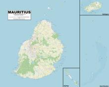
Mauritius is an island off Africa's southeast coast located in the Indian Ocean, east of Madagascar.
Area (includes Agaléga, Cargados Carajos (St. Brandon), and Rodrigues): total: 2,011 km2 land: 2,030 km2 water: 10 km2 note: includes Agalega Islands, Cargados Carajos Shoals (St. Brandon), and Rodrigues.
Coastline: 177 km Maritime claims: territorial sea: 12 nmi (22.2 km; 13.8 mi) continental shelf: 200 nmi (370.4 km; 230.2 mi) or to the edge of the continental margin exclusive economic zone: 200 nmi (370.4 km; 230.2 mi) Elevation extremes: lowest point: Indian Ocean 0 m highest point: Piton de la Petite Rivière Noire 828 m Natural resources: arable land, fish Land use: arable land: 38.24% permanent crops: 1.96% other: 59.80% (2011) Irrigated land: 212.2 km2 (2003) Total renewable water resources: 2.75 km3 (2011) Environment - current issues: water pollution, degradation of coral reefs, overfishing (Mauritius), sea wreck pollution[1] (Cargados Carajos Shoals), Illegal, unreported and unregulated fishing by foreign, primarily Taiwanese commercial vessels and Mauritian Fishing Cooperatives, invasive alien species, illegal net fishing in the St. Brandon Lagoon by unlicenced, non resident fishing operators.
Environment - international agreements: party to: Antarctic-Marine Living Resources, Biodiversity, Climate Change, Climate Change-Kyoto Protocol, Desertification, Endangered Species, Environmental Modification, Hazardous Wastes, Law of the Sea, Marine Life Conservation, Ozone Layer Protection, Ship Pollution, Wetlands Geography - note: The main island is from which the country derives its name, former home of the dodo, a large flightless bird related to pigeons, driven to extinction by the end of the 17th century through a combination of hunting and the introduction of predatory species.
The country's landscape consists of a small coastal plain rising to discontinuous mountains encircling a central plateau.