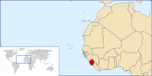
Geography of Sierra Leone
[1] Sierra Leone is located on the west coast of Africa, between the 7th and 10th parallels north of the equator.
Sierra Leone is bordered by Guinea to the north and northeast, Liberia to the south and southeast, and the Atlantic Ocean to the west.
[1] Sierra Leone has four distinct geographical regions: coastal Guinean mangroves, the wooded hill country, an upland plateau, and the eastern mountains.
Eastern Sierra Leone is an interior region of large plateaus interspersed with high mountains, where Mount Bintumani rises to 1,948 meters (6,391 ft).
Environmental problems include the overharvesting of timber, the expansion of cattle grazing and slash and burn agriculture have resulted in deforestation and soil exhaustion, and overfishing.