Geography of Senegal
Natural resources: fish, phosphates, iron ore Land use: arable land: 19.57% permanent crops: 0.28% other: 80.15% (2011) Irrigated land: 1,197 km2 (2003) Total renewable water resources: 38.8 km3 Natural hazards: lowlands seasonally flooded; periodic droughts Environment — current issues: wildlife populations threatened by poaching; deforestation; overgrazing; soil erosion; desertification; overfishing Senegal is a party to several environmental treaties: Senegal has signed, but not ratified, the Convention on Marine Dumping.
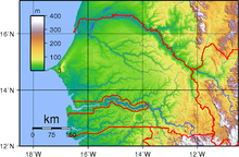
The highest point is Baunez ridge situated 2.7 km southeast of Nepen Diakha at 648 m (2,126 ft).
[5] The extreme north in the valley of the Senegal River has a hot arid climate (BWh) with a wet season largely confined to August and September and very high year-to-year variability with complete failure of the wet season not rare.
Climate change will cause an increase in average temperatures over west Africa by between 1.5 and 4 °C (3 °F and 7 °F) by mid-century, relative to 1986–2005.
[19][20] Although Senegal is currently not a major contributor to global greenhouse gas emissions, it is one of the countries most vulnerable to climate change.
[23] Senegal has a number of vegetation zones: sahel, Sahel-Sudan, Sudan (region), Sudan-Guinea, tropical rainforest, and Guinean mangroves.
[26] Most of the southern Casamance arm of the country has been classified by the World Wildlife Fund as part of the Guinean forest-savanna mosaic ecoregion.