Course of the Willamette River
Significant tributaries include the McKenzie, Long Tom, Marys, Calapooia, Santiam, Luckiamute, Yamhill, Molalla, Tualatin, and Clackamas rivers.
[1][6][7] At the Willamette's source, the confluence of the two forks, Dorris Ranch Living History Farm [ceb] is on the right and Franklin Boulevard is on the left.
Interstate 5 (I-5), co-terminous with Oregon Route 99 (Pacific Highway), is also on the left bank slightly further from the river than Franklin Boulevard.
[6][8][9][10] Meandering north, the river receives Spring Creek from the left about 4 miles (6 km) later, then flows around Marshall Island before reaching Linn County at about RM 167 (RK 269).
Curtis Slough enters from the right about 163 miles (262 km) from the mouth, where the river passes under bridges carrying the Southern Pacific and BNSF railways.
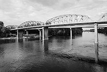
[6][9][13][14] In Albany, the river flows east under a Union Pacific railroad bridge and through the city, then curves north by a series of industrial ponds as well as First, Second, Third, and Fourth lakes, which are on the right.
North of Salem, the river passes the city of Keizer, which is on the right, before receiving Glenn Creek from the left about 79.5 miles (127.9 km) from the mouth.
About 2 miles (3 km) below the Yamhill, Chehalem Creek enters from the left, and then the river flows around Ash Island, where it receives High Water Slough from the right.
[6][9][16] At Newberg the river, which has been meandering north from Eugene, turns sharply east, passes under a pipeline bridge and, about 2 miles (3 km) later, under Oregon Route 219.
[6][9][17] The river then flows under the Boone Bridge, which carries Interstate 5 (I-5), and receives Boeckman Creek from the left about 1 mile (2 km) later.
Below Fish Eddy, the river passes Willow Island and New Era Bar before receiving Beaver Creek from the right, near Sevcik Pond.
From West Linn to Oregon City, I-205 and Willamette Falls Drive run roughly parallel to the river to its left.
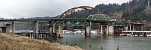
About 1 mile (2 km) later, Canemah, a neighborhood of Oregon City, is on the right and Tanner Creek enters from the left as the river approaches Willamette Falls.
About 1.5 miles (2.4 km) further downriver, Mary S. Young State Recreation Area is on the left, and then the river passes Cedar Island.
From Lake Oswego to near the Ross Island Bridge in Portland, Oregon Route 43 runs roughly parallel to the river and to its left.
The north–south leg of the Springwater Corridor, a pedestrian and bicycle path, runs parallel to the river along its right bank from Sellwood to the Hawthorne Bridge in central Portland.
Between the bridge and Sauvie Island, Route 30 runs roughly parallel to the left of the river between it and Forest Park in the Tualatin Mountains (West Hills).
Below this, Swan Island and its marine terminals, run by the Port of Portland, is on the right at about 10 miles (16 km) from the mouth, and Balch Creek enters from the left.
The Willamette then receives Saltzman and Doane creeks from the left before flowing under the Burlington Northern Railroad Bridge 5.1 at RM 7 (RK 11).
Over the final stretch of the river, the main channel flows north by Sauvie Island, which is on the left and marine terminals and industrial areas, which are on the right.
Kelley Point Park is to the right at the confluence of the Willamette and the Columbia, about 101 miles (163 km) from the larger river's mouth on the Pacific Ocean.
U.S. Route 30 and tracks of the Burlington Northern Railroad run roughly parallel to the channel, and to its left, between its source and the Multnomah–Columbia county border at about RM 12.5 (RK 20.1).
St. Helens is on the left as the channel enters the Columbia, about 86.5 miles (139.2 km) from the larger stream's mouth on the Pacific Ocean.
[14] The United States Geological Survey (USGS) operates four stream gauges along the river, at Harrisburg, Albany, Salem, and Portland.
[24] During the 115 years of 1894 plus 1896–2009, the average discharge recorded by a gauge at the Ellsworth Street Bridge in Albany, Oregon, at RM 119.31 (RK 192.01), was 14,210 cubic feet per second (402 m3/s).
Nine upstream dams on tributaries regulate the flow, which is also affected by diversions for irrigation, municipal water supplies, and electricity generation.
[23] A gauge at RM 84.16 (RK 135.44), near the Center Street Bridge in downtown Salem recorded an average discharge of 23,250 cubic feet per second (658 m3/s) over the 93 years between 1910–16 and 1924–2009.
Extremes outside the period of record include a maximum discharge of 500,000 cubic feet per second (14,158 m3/s) on December 4, 1861, based on flood marks and other data.
Located at RM 12.8 (RK 20.6), the gauge measures the flow from an area of 11,200 square miles (29,000 km2), roughly 97 percent of the Willamette basin.
[26] Extremes outside the period of record include flood maximums during the roughly 110 years before the Morrison Bridge gauge was put in place.