Geography of Michigan
Michigan consists of two peninsulas surrounded primarily by four of the Great Lakes and a variety of nearby islands.
Both land masses are also separated from the Canadian province of Ontario by waterways of the Great Lakes, and from each other by the Straits of Mackinac.
The state's highest point, in the Huron Mountains northwest of Marquette, is Mount Arvon at 1,979 feet (603 m).
The peninsula is as large as Connecticut, Delaware, Massachusetts, and Rhode Island combined but has fewer than 330,000 inhabitants.
The geographic orientation of Michigan's peninsulas makes for a long distance between the ends of the state.
The geographic isolation of the Upper Peninsula from Michigan's political and population centers makes the U.P.
The surface of the peninsula is generally level, broken by conical hills and glacial moraines usually not more than a few hundred feet tall.
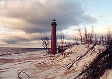
After Alaska, Michigan has the longest shoreline of any state[citation needed], 3,288 miles (5,292 km).
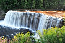
[5] The state's numerous rivers are generally short and shallow, though several are navigable by recreational watercraft.
During the winter through the middle of February parts of the state are frequently subjected to heavy lake-effect snow.
Snow cover tends to be intermittent in the southern part of the state, but persistent in northern Lower Michigan and especially in the Upper Peninsula.
The Upper Peninsula exhibits Lower Silurian sandstones, limestones, copper and iron bearing rocks, corresponding to the Huronian system of Canada.
The central portion of the Lower Peninsula contains coal measures and rocks of the Permo-Carboniferous period.
The principal forest trees include basswood, maple, elm, sassafras, butternut, walnut, poplar, hickory, oak, willow, pine, birch, beech, hemlock, witchhazel, tamarack, cedar, locust, dogwood, and ash.