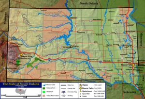
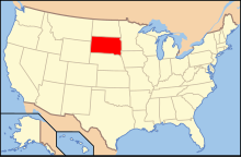
Geography of South Dakota
Geologic formations in South Dakota range in age from two billion-year-old Precambrian granite in the Black Hills to glacial till deposited over the last few million years.
The western border is the Black Hills meridian, a north-south line set out at a certain distance from Washington, D.C., to separate South Dakota from Montana and Wyoming during the transition to statehood.
Smaller geographic regions of this area include the Coteau des Prairies, the Dissected Till Plains, and the James River Valley.
[12] Numerous glacial lakes cover the Coteau, and it is largely drained by the Big Sioux River, a tributary of the Missouri.
The Dissected Till Plains, an area of rolling hills and fertile soil that covers much of Iowa and Nebraska, also extends into the southeastern corner of South Dakota.
The oldest geologic formations in the state were created over two billion years ago during the Precambrian, and consist of metamorphic and igneous rocks.
[18][19] These form the central core of the Black Hills, but they can also be found in two isolated locations in eastern South Dakota near Milbank and Sioux Falls.
[18] Formations from the Paleozoic Era form the outer ring of the Black Hills; these were created between roughly 540 and 250 million years ago.
Many of these sediments ended up in the same area as the marine deposits from the inland sea, and both contribute to western South Dakota's present-day geological makeup.
[18] Layers deposited during the Pleistocene epoch, starting around two million years ago, cover most of eastern South Dakota.
Gold seekers founded most of the larger cities around the Black Hills, and quarrying was an important economic activity in several areas in eastern South Dakota.
Mines and quarries in present-day South Dakota produce gold,[24] Sioux quartzite, Milbank granite, sand, gravel, limestone, mica, and uranium.
[25] The vast majority of South Dakota's natural lakes are located in the eastern half of the state, and most are the product of the most recent ice age.
[29] Although grasses and crops cover most of this region, deciduous trees such as cottonwoods, elms, and willows are common near rivers and in shelter belts.
[31] The Missouri River also contains the pre-historic paddlefish,[33] and chinook salmon, native to the Pacific Northwest, have been successfully introduced in Lake Oahe.
The tall grass prairies have wild rose and buck bush shrubs, and goldenrod, sunflower, cinquefoil, and milkweed herbs.
While antelope and bison were common in prior centuries, modern animal life consists of deer, jackrabbit, skunk, badger, pocket gopher, and weasel.
Many birds have their habitat here: geese, ducks, falcons, hawks, turkey buzzards, owls, sparrows, larks, blackbirds, and more.
Evening primroses, prairie lilies, blazing star, aster, goldenrod, sunflower, and wild onions are common plants.
The mountains are thickly blanketed by coniferous needleleaf evergreens: various types of pines—including ponderosa (covering 1,000,000 acres (400,000 ha), or 80% of the Black Hills forest[35]), lodgepole, white, and timber—as well as western red cedar and spruces.
The Red Valley is home to blue-joint and bluegrasses, and wild plum, Juneberry, and chokecherry shrubs grow in the Hills.
Vines grow widely: the woodbine, bittersweet, and wild grape, which is the pattern for Black Hills gold jewelry.
[31] The prairie serves as home to songbirds such as meadowlarks (both the eastern and western varieties), goldfinches, and bluebirds, and the open landscape of the plains also suits many carnivorous birds, such as hawks, falcons, and owls.
[31] South Dakota has a continental climate, semi-arid in the west outside of the Black Hills, with four distinct seasons, ranging from very cold winters to hot summers.
American Indians, largely Lakota, Dakota, and Nakota (Sioux) are predominant in several counties, mostly in the western part of the state.
[72] The growth in these areas has compensated for losses in the rest of the state, and South Dakota's total population continues to increase steadily, albeit at a slower rate than the national average.
[80] The economy of Sioux Falls, originally focused on agri-business and quarrying, has recently become largely centered on retail and financial services.
The next eight largest cities in the state, in order of descending 2007 population, are Aberdeen (24,410), Watertown (20,530), Brookings (19,463), Mitchell (14,832), Pierre (14,032), Yankton (13,643), Huron (10,902), and Vermillion (10,251).
Although other industries have expanded rapidly in recent decades, agricultural production is still very important to the state's economy, especially in rural areas.
South Dakota's location between national parks in the west and large cities to the east also contributes to the state's tourism and hospitality industry.