Geography of Oklahoma
[4] More than 500 named creeks and rivers make up Oklahoma's waterways, and with 200 lakes created by dams, it holds the highest number of reservoirs in the nation.
Situated between the Great Plains and the Ozark Plateau in the Gulf of Mexico watershed,[6] Oklahoma tends to slope gradually downward from its western to eastern boundaries.
[9] In the state's northwestern corner, semi-arid high plains harbor few natural forests and rolling to flat landscape with intermittent canyons and mesa ranges like the Glass Mountains.
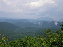
The Ozark and Ouachita (pronounced Oh-Wa-Sheet-ah) Mountains rise from west to east over the state's eastern third, gradually increasing in elevation in an eastward direction.
The prolonged drought that started in 1930 and created the condition called the "Dust Bowl", led to the construction of a great many reservoirs throughout the state.
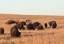
[9][10][11] The state holds large populations of white-tailed deer, coyotes, bobcats, elk, and birds such as quail, doves, cardinals, bald eagles, red-tailed hawks, and pheasants.
[20] Most of the state lies in an area known as Tornado Alley characterized by frequent interaction between cold and warm air masses, producing severe weather, with the highest-risk months from April to June.
[21] Due to its position between zones of differing prevailing temperature and winds, weather patterns within the state can vary widely between relatively short distances.
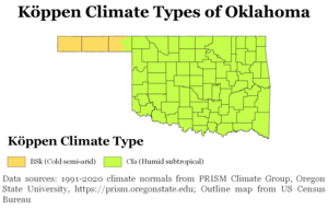
This transitions progressively to a semi-arid zone (Köppen BSk) in the high plains of the Panhandle, where a drier climate prevails, with somewhat-colder winters and similarly-hot summers but much lower humidity.
Other central to western areas of the state, including Lawton and Enid in the transition zone, are also less affected by moisture from the Gulf of Mexico.
Winters during El Niño are cooler than average and wetter across the western portion of the state due to an amplified southern jet stream.