Fulton County, Pennsylvania
It has a humid continental climate (Dfa/Dfb) and average monthly temperatures in McConnellsburg range from 29.2 °F in January to 73.0 °F in July.
[6] Fulton County is one of the 423 counties served by the Appalachian Regional Commission,[7] and it is identified as part of "Greater Appalachia" by Colin Woodard in his book American Nations: A History of the Eleven Rival Regional Cultures of North America.
[8] Fulton County is situated within the Ridge and Valley physiographic province, which is characterized by folded and faulted sedimentary rocks of early to middle Paleozoic age.
[9] The stratigraphic record of sedimentary rocks within the county spans from the Cambrian Shadygrove Formation outcropping just south of McConnellsburg to the Pennsylvanian Allegheny Group at the northernmost tip of the county.
[10] However, during the Pleistocene epoch, or "Ice Age," periglacial (meaning "around glacier" or simply "cold") processes dominated.
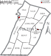
The Broad Top Coal Field is located in Wells Township in the northwestern corner of the county.
The dominant form of speech in Fulton County is the Central Pennsylvania accent.
Although Fulton County traditionally voted Democratic in the 19th and early 20th centuries, and Democrats held the edge in voter registration in the county until the late 20th century, it has displayed strong tendencies to vote for Republican candidates since the New Deal era.
In 2006, Rick Santorum and Lynn Swann received more than 60% of the Fulton County vote despite their defeats statewide.
[21] Under Pennsylvania law, there are four types of incorporated municipalities: cities, boroughs, townships, and, in at most two cases, towns.