Geography of Alaska
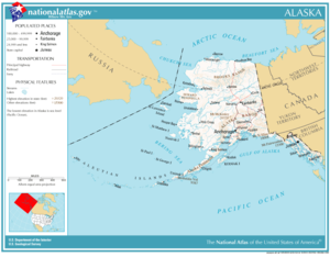
Alaska occupies the northwestern portion of the North American continent and is bordered only by Canada on the east.
[1] About 500 miles (800 km) of Canadian territory consisting of British Columbia (in Canada) separate Alaska from Washington U.S. state.
Alaska is thus an exclave of the United States that is part of the continental U.S. and the U.S. West Coast, but is not part of the contiguous U.S.[2] The state is bordered by Yukon and British Columbia, Canada to the east, the Gulf of Alaska and the Pacific Ocean to the south, Russia (Chukotka Autonomous Okrug), Bering Sea, the Bering Strait, and the Chukchi Sea to the west, and the Beaufort Sea and the Arctic Ocean to the north.
[3] Marshlands and wetland permafrost cover 188,320 square miles (487,700 km2) (mostly in northern, western and southwest flatlands).
The Bering Glacier complex near the southeastern border with Yukon, Canada, covers 2,250 square miles (5,800 km2) alone.
A location in the National Petroleum Reserve–Alaska is 120 miles (190 km) from any town or village, the geographic point most remote from permanent habitation in the United States.
For example, Unimak Island is home to Mount Shishaldin, a moderately active volcano that rises to 9,980 feet (3,042 m) above sea level.
[4]) The Aleutian Islands cross longitude 180°, so Alaska can be considered the easternmost state as well as the westernmost.
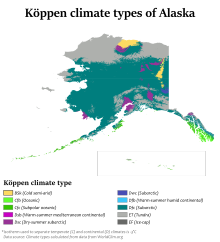
On an annual basis, the southeast is both the wettest and warmest part of Alaska with milder temperatures in the winter and high precipitation throughout the year.
[6] This is also the only region in Alaska in which the average daytime high temperature is above freezing during the winter months.
The climate of Anchorage and south central Alaska is mild by Alaskan standards due to the region's proximity to the seacoast.
An area stretching from the northern side of the Seward Peninsula to the Kobuk River valley (i.e., the region around Kotzebue Sound) is technically a desert, with portions receiving less than 10 in (25 cm) of precipitation annually.
[12] The climate in the extreme north of Alaska is Arctic (Köppen: ET) with long, very cold winters and short, cool summers.