Geography of Arkansas
The state is covered by mountains, river valleys, forests, lakes, and bayous in addition to the cities of Arkansas.
[6] Arkansas is located in the southeastern United States, in the West South Central Census Bureau division.
Arkansas covers an area of 53,179 square miles (137,733 km²) and ranks as the 29th largest state by size.
[8] This was further divided into the Arkansaw Territory on March 2, 1819, as everything south of Parallel 36°30′ north (except the Missouri Bootheel) to the Louisiana state line.
The Choctaws wanted the western boundary of Arkansas to start 100 paces east of Fort Smith and run south to the Red River, claiming the land had little timber and poor soil.
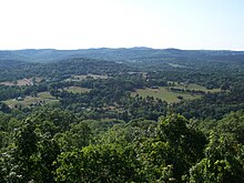
Northwest Arkansas contains the southern half of the Ozarks, including the steeper Boston Mountains and the more gentle Springfield Plateau.
[10] The Ozark National Forest, administered by the National Forest Service, preserves 1,200,000 acres (490,000 ha) of land in northwest Arkansas, including Arkansas's highest point, Mount Magazine in Mount Magazine State Park.
[13] Northeast Arkansas is generally characterized as the area east of the Ozark Mountains and north of Interstate 40.
The exception is Crowley's Ridge, a geological remnant from the Pleistocene era that raises around 200 feet (61 m) above the surrounding delta lowlands.
Following settlement, most of the area relied on cotton as the primary cash crop, and was home to many powerful plantation owners in the antebellum period.
After the Civil War, agriculture became based on sharecropping and tenant farming, allowing plantation owners to keep their workers in poverty and maintain their political power.
The rivers served as highways for commerce and communication in the early days, and steamboat towns of days past have been restored for visitors to enjoy, including Jacksonport State Park and Powhatan Historic State Park along the Black River.
The western side of Southeast Arkansas includes the Piney Woods, a region known for dense pine and cypress forests.
Following widespread settlement, most of the area was put into cotton cultivation due to the region's fertile soils.
After the Civil War, agriculture became based on sharecropping and tenant farming, allowing plantation owners to keep their workers in poverty and maintain their political power and social dominance.
In the 1950s, mechanization reduced the need for laborers on the farm, driving much of the region's population elsewhere in order to find jobs.
Most of Southwest Arkansas is sparsely populated, with small towns separated by long roadways through stands of pine trees.
While not bordering the Gulf of Mexico, Arkansas is still close enough to the warm, large body of water for it to influence the weather in the state.
Generally, Arkansas has hot, humid summers and slightly drier, mild to cool winters.
While sufficiently far from the coast to avoid a direct hit from a hurricane, Arkansas can often get the remnants of a tropical system, which dumps tremendous amounts of rain in a short time and often spawns smaller tornadoes.
[citation needed] The Natural Resources Conservation Service has noted that amounts of rainfall in Arkansas are characterized by marked differences along a northeast/southwest dividing line.
In many upland regions of Arkansas, surface water interacts with groundwater via karst topography common to the Ozarks and Ouachitas.