Geography of Benin
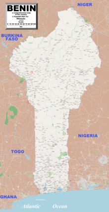
Its latitude ranges from 6°30′ N to 12°30′ N and its longitude from 1° E to 3°40′ E. It is bounded by Togo to the west, Burkina Faso and Niger to the north, Nigeria to the east, and the Bight of Benin to the south.
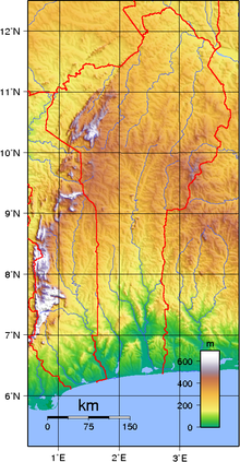
The plateaus of southern Benin, with an altitude ranging between 20 and 200 m (66 and 656 ft), are split by valleys running north to south along the Couffo, Zou, and Oueme Rivers, an area that has been categorised by the World Wildlife Fund as part of the Guinean forest-savanna mosaic ecoregion.
Then an area of flat lands dotted with rocky hills whose altitude seldom reaches 400 m (1,312 ft) extends around Nikki and Savé.
Finally, the Atacora mountain range extends along the northwest border and into Togo with the highest point, Mont Sokbaro, at 658 m (2,159 ft).
The country formerly offered habitat for the endangered painted hunting dog, Lycaon pictus,[3] although this canid is considered to have been extirpated from Benin due to human population expansion.
Continent: Africa Area: total: 112 622 km2 country comparison to the world: 102 land: 110 622 km2 water: 2 000 km2 Area comparative Land boundaries: total: 2 123 km border countries: Burkina Faso 386 km, Niger 277 km, Nigeria 809 km, Togo 651 km Coastline: 121 km Maritime claims: territorial sea: 200 nautical miles (370.4 km) Climate: tropical; hot, humid in south; semiarid in north Terrain: mostly flat to undulating plain; some hills and low mountains Elevation extremes: lowest point: Atlantic Ocean 0 m highest point: Mont Sokbaro 658 m Natural resources: small offshore oil deposits, limestone, marble, timber Land use: arable land: 23.94% permanent crops: 3.99% other: 72.06% (2012) Irrigated land: 230.4 km2 (2012) 'Total renewable water resources: 26.39 km3 (2011) Freshwater withdrawal (domestic/industrial/agricultural): total: 0.13 km3/a (32%/23%/45%) per capita: 18.74 m3/a (2001) Natural hazards: hot, dry, dusty harmattan wind may affect north in December to March Environment - current issues: inadequate supplies of potable water; poaching threatens wildlife populations; deforestation; desertification Environment - international agreements: party to: Biodiversity, Climate Change, Climate Change-Kyoto Protocol Desertification, Endangered Species, Environmental Modification, Hazardous Wastes, Law of the Sea, Ozone Layer Protection, Ship Pollution, Wetlands, Whaling Sandbanks create difficult access to a coast with no natural harbors, river mouths, or islands.
Grass dries up, the vegetation turns reddish brown, and a veil of fine dust hangs over the country, causing the skies to be overcast.