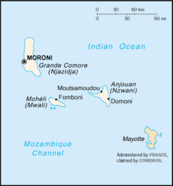
Geography of the Comoros
Three mountain chains — Sima, Nioumakele, and Jimilime—emanate from a central peak, Mtingui (1,575 m), giving the island its distinctive shape.
A coral reef lies close to shore; the island's capital of Mutsamudu is also its main port.
A well-developed coral reef that encircles much of the island ensures protection for ships and a habitat for fish.
Dzaoudzi, capital of the Comoros until 1962 and now Mayotte's administrative center, is situated on a rocky outcropping off the east shore of the main island.
Dzaoudzi is linked by a causeway to le Pamanzi, which at ten kilometers in area is the largest of several islets adjacent to Mayotte.
A live specimen was caught in 1938 off southern Africa; other coelacanths have since been found in the vicinity of the Comoro Islands.
A British preservation group sent an expedition to the Comoros in 1992 to bring some of the bats to Britain to establish a breeding population.
A hybrid of the common brown lemur (Eulemur fulvus) originally from Madagascar, was introduced by humans prior to European colonization and is found on Mayotte.
[1] The mongoose lemur (Eulemur mongoz), also introduced from Madagascar by humans, can be found on the islands of Mohéli and Anjouan.
Specifically, to minimize the cutting down of trees for fuel, kerosene is being subsidized, and efforts are being made to replace the loss of the forest cover caused by ylang-ylang distillation for perfume.
Area: 2,235 km2 Coastline: 340 km Climate: tropical marine; rainy season (November to May) Terrain: volcanic islands, interiors vary from steep mountains to low hills Elevation extremes: lowest point: Indian Ocean 0 m highest point: Karthala 2,360 m Natural resources: fish Land use: arable land: 47.29% permanent crops: 29.55% other: 23.16% (2012 est.)
Irrigated land: 1.3 km2 (2003) Total renewable water resources: 1.2 km3 (2011) Freshwater withdrawal (domestic/industrial/agricultural): total: 0.01 km3/yr (48%/5%/47%) per capital: 16.86 m3/yr (1999) Natural hazards: cyclones possible during rainy season (December to April); volcanic activity on Grand Comore Environmental - current issues: soil degradation and erosion results from crop cultivation on slopes without proper terracing; deforestation