Geography of Florida
[1] Florida is one of the largest states east of the Mississippi River, and only Alaska and Michigan are larger in water area.
The coastal lowlands rim the entirety of the peninsula and panhandle from the shoreline to 30 to 50 miles (48 to 80 km) inland, merging with the Interior Highland.
[2] At 345 feet (105 m) above mean sea level, Britton Hill in northern Walton County is the highest point in Florida and the lowest known highpoint of any U.S.
[3] Much of the state south of Orlando is low-lying and fairly level; however, some places, such as Clearwater, feature vistas that rise 50 to 100 feet (15 to 30 m) above the water.
Much of Central and North Florida, typically 25 miles (40 km) or more away from the coastline, features rolling hills with elevations ranging from 100 to 250 feet (30 to 76 m).
Miami and other parts of south Florida are the most vulnerable regions in the world to rising sea levels associated with climate change.
[6] Due to the vast amounts of limestone bedrock that Florida sits above, water is allowed to move relatively freely beneath dry land and to rise up to the surface.
[8] The state line begins in the Atlantic Ocean, traveling west, south, and north up the thalweg of the Saint Mary's River.
The emergent portion of the platform was created during the Eocene to Oligocene as the Gulf Trough filled with silts, clays, and sands.
[9] Extended systems of underwater caves, sinkholes and springs are found throughout the state and supply most of the water used by residents.
The limestone is topped with sandy soils deposited as ancient beaches over millions of years as global sea levels rose and fell.
During the last glacial period, lower sea levels and a drier climate revealed a much wider peninsula, largely savanna.
[citation needed] In January 1880, Cuba was the center of two strong earthquakes that sent severe shock waves through the city of Key West, Florida.
These thunderstorms, caused by overland collisions of moist masses of air from the Gulf of Mexico and Atlantic Ocean[citation needed], pop up in the early afternoon and can bring heavy downpours, high winds, and sometimes, tornadoes.
Florida leads the United States in tornadoes per square mile (when including waterspouts),[27] but they do not typically reach the intensity of those in the Midwest and Great Plains.
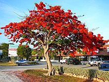
A narrow eastern part of the state including Orlando and Jacksonville receives between 2,400 and 2,800 hours of sunshine annually.
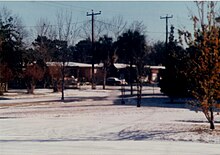
The most widespread snowfall in Florida history occurred on January 19, 1977, when snow fell over much of the state, with flurries as far south as Homestead.
More recently, traces of snow and sleet fell across central Florida during a hard freeze event in January, 2010.
Wilma is the second most expensive hurricane in Florida history, due in part to a five-year window in which to file claims.
[34] Florida was the site of the second costliest weather disaster in U.S. history, Hurricane Andrew, which caused more than US$25 billion in damage when it struck on August 24, 1992.
[42] Florida's extensive coastline made it a perceived target during World War II, so the government built airstrips throughout the state; today, approximately 400 airports are still in service.