Geography of Georgia (U.S. state)
Georgia's subtropical climate depends on latitude and how close an area is to the Atlantic Ocean or the Gulf of Mexico.
This folding and faulting created a series of ridges and valleys that vary in "height, width and geological materials".
[7] It includes igneous, metamorphic, and sedimentary geology; the main types of rocks in the area are gneiss, slate and saprolite.
[8] The Blue Ridge consists primarily of Precambrian metamorphic rocks, and the landscape has relatively high relief.
The Piedmont region consists of Paleozoic metamorphic and igneous rocks, and the landscape has relatively low relief.
[8] Georgia's coastal plain is made up of sedimentary rock dating from the Late Cretaceous to Holocene periods.
Approximately 1 billion years ago a metamorphic change occurred during an event called the Grenville Orogeny and caused the rocks, which were originally sediment, to compress into a form of rock called gneiss due to heat and pressure.
Around 630 million years ago the Grenville mountains began to erode carrying sediments from streams to the sea.
The gneiss formed from these sediments created the marble, metaconglomerate, phyllite, quartzite, schist, and slate found in the Blue Ridge and Piedmont areas.
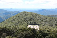
Brasstown Bald, the highest mountain in Georgia at 4,784 feet (1,458 m) above mean sea level,[13] is part of the chain and sits in an area known as Wolfpen Ridge.
The mountain is known for its geology and also for its enormous bas-relief depicting three Confederate leaders: Jefferson Davis, Robert E. Lee and Thomas J.
[16] The river begins in the Blue Ridge Mountains just below Brasstown Bald and ends at Lake Seminole in the southwesternmost corner of Georgia where it creates a boundary between Alabama and Florida.
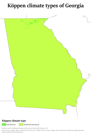
[25] The majority of Georgia has primarily a humid subtropical climate tempered somewhat by occasional polar air masses in the winter.
The entire state, including the north Georgia mountains, receives moderate to heavy precipitation, which varies from 45 inches (1,100 mm) in central Georgia[26] to approximately 75 inches (1,900 mm) around the Northeast part of the state.
[27] The degree to which the weather of a certain area of Georgia is subtropical depends not just on the latitude, but also on how close it is to the Atlantic Ocean or Gulf of Mexico and the altitude.
This is especially true in the mountainous areas in the northern part of the state, which are further away from ocean waters and can be up to 4,500 feet (1,400 m) or higher above sea level.
More common are hurricanes which strike the Florida panhandle, weaken over land, and bring strong tropical storm winds and heavy rain to the Georgia interior, as well as hurricanes that come close to the Georgia coastline, brushing the coast on their recurvature on the way up to hit the Carolinas.
Studies show that Georgia is among a string of "Deep South" states that will experience the worst effects of climate change,[38][39] with effects including "more severe floods and drought", and higher water levels "eroding beaches, submerging low lands, and exacerbating coastal flooding.
[42] Both the agricultural areas and the waters of Georgia have created a thriving environment for hunting, fishing and game.
[42] The geological resources of Georgia include many types of minerals, manganese, iron ore, copper, coal, oil, clays, stone, kaolin, sand and gravel.