Geography of Japan
The subduction plates have pulled the Japanese archipelago eastward, created the Sea of Japan, and separated it from the Asian continent by back-arc spreading 15 million years ago.
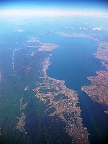
Three of the four major islands (Honshu, Kyushu, and Shikoku) are separated by narrow straits of the Seto Inland Sea and form a natural entity.
Kyushu is closest to the southernmost point of the Korean peninsula, with a distance of 190 km (120 mi), which is almost six times farther away than from England to France across the English Channel.
During the Paleolithic period around 20,000 BCE, at the height of the Last Glacial Maximum, there was a land bridge between Hokkaido and Sakhalin that linked Japan with the Asian continent.
[25] Japan's remote location, surrounded by vast seas, rugged, mountainous terrain, and steep rivers, makes it secure against invaders and uncontrolled migration from the Asian continent.
[27] Central Japan is marked by the convergence of the three mountain chains—the Hida, Kiso, and Akaishi mountains—that form the Japanese Alps (Nihon Arupusu), several of whose peaks are higher than 3,000 metres (9,800 ft).
[27] The highest point in the country is Mount Fuji (Fujisan, also erroneously called Fujiyama), a volcano dormant since 1707 that rises to 3,776 m (12,388 ft) above sea level in Shizuoka Prefecture.
[27] The Pacific coastline south of Tokyo is characterized by long, narrow, gradually shallowing inlets produced by sedimentation, which has created many natural harbors.
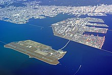
Large land reclamation projects with landfills were done in coastal areas for maritime and industrial factories, such as Higashi Ogishima in Kawasaki, Osaka Bay, and Nagasaki Airport.
The Tokyo Metropolitan Government spent an additional 3.8 billion yen ($33.5 million) to pump out groundwater by digging hundreds of wells.
Approximately 15,000 km (9,300 mi) of oceanic floor has passed under the Japanese archipelago in the last 450 million years, with most being fully subducted.
[65] The Japanese archipelago grows gradually because of perpetual tectonic plate movements, earthquakes, stratovolcanoes, and land reclamation in the Ring of Fire.
[75] During the Pleistocene (spanning 2.58 million-11,700 years ago) glacial cycles, the Japanese islands may have occasionally been connected to the Eurasian Continent via the Korea Strait and the Korean Peninsula or Sakhalin.
[96] Offshore fisheries accounted for an average of 50% of the nation's total fish catches in the late 1980s, although they experienced repeated ups and downs during that period.
[27] As Mount Fuji and the coastal Japanese Alps provide a rain shadow, Nagano and Yamanashi Prefectures receive the least precipitation in Honshu, though it still exceeds 900 millimetres (35 in) annually.
The climate from June to September is marked by hot, wet weather brought by tropical airflows from the Pacific Ocean and Southeast Asia.
In summer, however, sunshine hours are lowest on exposed parts of the Pacific coast, where fogs from the Oyashio current create persistent cloud cover similar to that found on the Kuril Islands and Sakhalin.
The high humidity and the maritime influence make temperatures in the 40s rare, with summers dominated by a more stable subtropical monsoon pattern through most of Japan.
Satellite images at night show a dense and continuous strip of light (demarcating urban zones) that delineates the region with overlapping metropolitan areas in Japan.
In an area that was possibly reclaimed in the past, old maps and land condition drawings are checked, and drilling is carried out to determine the strength of the ground.
Beginning in June, repeated collapse of this erupting dome generated ash flows that swept down the mountain's slopes at speeds as high as 200 km/h (120 mph).
[149][150] The Hōei eruption of Mount Fuji did not have a lava flow, but it did release some 800 million cubic metres (28×10^9 cu ft) of volcanic ash.
300,000 to 90,000 years ago, there were four eruptions of Mount Aso that emitted huge amounts of volcanic ash that covered all of Kyushu and up to Yamaguchi Prefecture.
Surveys by KOBEC (Kobe Ocean-Bottom Exploration Center) confirm that a giant lava dome of 23 cubic kilometers formed after the Kikai Caldera erupted in 4,300 BC.
Professor Yoshiyuki Tatsumi, head of KOBEC, told the Mainichi Shimbun that "the probability of a gigantic caldera eruption hitting the Japanese archipelago is 1 percent in the next 100 years" with a death toll of many tens of millions of people and wildlife.
[158] The potential exists for tens of millions of humans and other living beings to die during a VEI-7 volcanic eruption with significant short-term effects on the global climate.
If, in another scenario, the wind blows in a western or southern direction, then the volcanic ash could affect the East Asian continent or South-East Asia.
The most protective measure is to stop the hot ash clouds from spreading and devastating areas near the eruption so that people don't need to evacuate.
In 2018, NASA published a theoretical plan to prevent a volcanic eruption by pumping large quantities of cold water down a borehole into the hydrothermal system of a supervolcano.
Since the 1960s, improvements in construction, flood prevention, high tide detection, and early warnings have substantially reduced the death toll, which rarely exceeds a dozen people per typhoon.