Geography of North Carolina
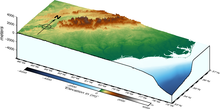
The physical characteristics of the state vary from the summits of the Smoky Mountains, an altitude of near seven thousand feet (2,130 m) in the west, sloping eastward to sea level along the coast and beaches of the Atlantic Ocean.
The Smoky Mountain chain (as contrasted with the Blue Ridge) is more continuous, more elevated, more regular in its direction and height, and rises very uniformly from 5,000 to 6,621 feet (2,018.1 m).
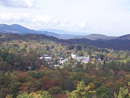
The eastern slopes of the Blue Ridge rise sharply from 1,500 to 4,500 feet (1,370 m) above the terrain to the east; to observers they often appear as a vast, lofty wall running across the state's western horizon.
The last, the Uwharrie range, sometimes presents a succession of elevated ridges, then a number of bold and isolated knobs, which often appear higher than they actually are, due to the relative flatness of the surrounding terrain.
East of the fall line, most of the coastal plain is relatively flat, with sandy soils ideal for growing tobacco, cotton, soybeans, and melons.
The coastal plain is covered by thick forests of pines and other evergreens; due to the sandy soils it is difficult for many deciduous trees to grow.
The easternmost portion of the state contains the Outer Banks, sandy islands that do not have coral reefs to attach to and thus are constantly shifting their locations.
The Outer Banks are known as the "Graveyard of the Atlantic" because numerous ships have been wrecked along their beaches and shoals due to storms and strong tides.
Despite the fact that North Carolina has hundreds of miles of beachfront territory, due to the Outer Banks and swampland along the coast the state lacks a good natural harbor.
Wilmington, located 15 miles (24 km) up the Cape Fear River, and Morehead City located on the other side of the bridge from Atlantic beach crossing the Bogue Sound remain the state's only two major ports; the Cape Fear river often has to be dredged to keep it open to large merchant marine ships.
The Carolina Sandhills is a 10-35 mi wide physiographic region within the innermost part of the Atlantic Coastal Plain province.
In the central part of the state, rivers flow generally southward into South Carolina before reaching the Atlantic Ocean.
In the eastern part of the state, most of the rivers flow generally in an eastward or southeastward direction, before emptying into one of the sounds that separate the mainland of North Carolina from the Outer Banks.
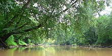
Many of those rivers are navigable far inland, owing to their breadth as they traverse the low, flat Atlantic Coastal Plain in the eastern part of the state.
On the ocean side, in winter, is the moderating influence of the warm Gulf Stream, the current of which sweeps along near its shores.