Geology of Mercury
In planetary science, the term geology is used in its broadest sense to mean the study of the solid parts of planets and moons.
This stems largely from its proximity to the Sun which makes reaching it with spacecraft technically challenging and Earth-based observations difficult.
For decades, the principal source of geologic information about Mercury came from the 2,700 images taken by the Mariner 10 spacecraft during three flybys of the planet from 1974 to 1975.
[2] This dearth of information was greatly alleviated by the MErcury Surface, Space ENvironment, GEochemistry, and Ranging (MESSENGER) spacecraft which between 2008 and 2015 collected over 291,000 images [3] covering the entire planet, along with a wealth of other scientific data.
Mercury's surface is dominated by impact craters, basaltic rock and smooth plains, many of them a result of flood volcanism, similar in some respects to the lunar maria,[4][5] and locally by pyroclastic deposits.
[6] Other notable features include vents which appear to be the source of magma-carved valleys, often-grouped irregular-shaped depressions termed "hollows" that are believed to be the result of collapsed magma chambers,[7] scarps indicative of thrust faulting, and mineral deposits (possibly ice) inside craters at the poles.
[11] This shift suggests there being one or more iron-rich molten layers surrounding the core producing a dynamo effect similar to that of Earth.
In order to land safely or enter a stable orbit the spacecraft must rely entirely on rocket motors because Mercury has negligible atmosphere.
Furthermore, the space environment near Mercury is demanding, posing the double dangers to spacecraft of intense solar radiation and high temperatures.
Historically, a second obstacle has been that Mercury's period of rotation is a slow 58 Earth days,[13] so that spacecraft flybys are restricted to viewing only a single illuminated hemisphere.
This was because Mariner 10's orbital period was almost exactly 3 sidereal Mercury days, and the same face of the planet was lit at each of the close approaches.
[14] After the formation of Mercury along with the rest of the Solar System 4.6 billion years ago, heavy bombardment by asteroids and comets ensued.
It caused lava eruptions and left a concentric ring over 2 km tall surrounding the impact crater.
The favoured hypothesis for the origin of this geomorphologic unit is that shock waves generated during the impact traveled around the planet, and when they converged at the basin's antipode (180 degrees away) the high stresses were capable of fracturing the surface.
These are made by ejected debris, which tend to be brighter while they remain relatively fresh because of a lesser amount of space weathering than the surrounding older terrain.
[9] Pit craters are rimless, often irregularly shaped, and steep-sided, and they display no associated ejecta or lava flows but are typically distinctive in color.
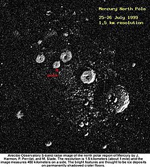
Non-crater surface features are given the following names: The first radar observations of Mercury were carried out by the radiotelescopes at Arecibo (Puerto Rico) and Goldstone (California, United States), with assistance from the U.S. National Radio Astronomy Observatory Very Large Array (VLA) facility in New Mexico.
This study not only confirmed the existence of the zones of high reflectivity and depolarization, but also found a number of new areas (bringing the total to 20) and was even able to survey the poles.
Craters at Mercury's higher latitudes (discovered by radar surveys from Earth as well) may be deep enough to shield the ice from direct sunlight.
It is therefore conceivable for meteorite impacts to have deposited water in the permanently shadow craters, where it would remain unwarmed for possibly billions of years due to the lack of an atmosphere to efficiently conduct heat and stable orientation of Mercury's rotation axis.