Ramapo Fault
[1] Spanning more than 185 miles (298 km) in New York, New Jersey, and Pennsylvania, it is perhaps the best known fault zone in the Mid-Atlantic region, and some small earthquakes have been known to occur in its vicinity.
This complex structure was formed during the past half billion years when the Earth's crust underlying the Northern Appalachians was the site of two major geological episodes, each of which has left its imprint on the NYC area bedrock.
A magnitude 4.0 eastern U.S. earthquake typically can be felt as far as 100 km (60 mi) from its epicenter, but it infrequently causes damage near its source.
The seismicity of the northeastern U.S. is generally considered to be due to ancient zones of weakness that are being reactivated in the present-day stress field.
In this model, pre-existing faults that were formed during ancient geological episodes persist in the intraplate crust, and earthquakes occur when the present-day stress is released along these zones of weakness.
Given the current geological and seismological data, it is difficult to determine if a known fault is still active today and could produce a modern earthquake.
Westernmost is the Valley and Ridge Province, made up of layers of Cambrian-Devonian sedimentary limestone, sandstone, and shale remaining from ancient sea sediment, sand, and mud.
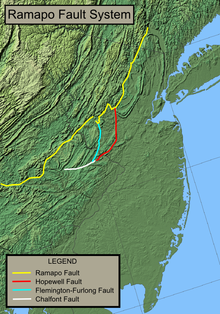
The Ramapo Fault forms the boundary between the Newark Basin and the Highlands, running from Haverstraw, New York to near Schaefferstown, Pennsylvania.
The Newark Basin, an aborted rift valley created during the breakup of Pangaea, consists of sedimentary and volcanic rocks from the Triassic and early Jurassic.
[13] The fault became integrally involved in a period of intense rifting, slowly lowering the land to its east by more than nine kilometers to create the Newark Basin.
[21] Magma was able to seep through linear fractures along the fault during the late Triassic and early Jurassic, producing episodic flood basalts responsible for the creation of the Watchung Mountains.
A 2008 study argued that a magnitude 6 or 7 earthquake was destined to originate from the Ramapo fault zone, which would almost definitely spawn hundreds or even thousands of fatalities and billions of dollars in damage.