Hurricane Ida (2009)
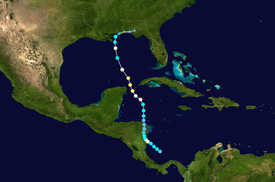
Ida formed on November 4 in the southwestern Caribbean, and within 24 hours struck the Nicaragua coast with winds of 80 mph (130 km/h).
Hurricane Ida weakened and became an extratropical cyclone in the northern Gulf of Mexico, before spreading across the southeastern United States.
By November 4, the low had become sufficiently organized for the National Hurricane Center (NHC) to classify it as Tropical Depression Eleven.
[1] Light wind shear allowed Ida to quickly intensify as it slowly tracked towards the Nicaraguan coastline.
[1] Very warm sea surface temperatures ahead of the system would have allowed for substantial intensification; however, wind shear over the area quickly increased, resulting in modest strengthening.
[6] Later that day, the storm turned northwestward in response to a strong trough over Mexico and a mid-level ridge extending from the Southeast United States to Hispaniola.
[1] Late on November 8, Ida attained its peak intensity with winds of 105 mph (170 km/h) and a barometric pressure of 975 mbar (hPa; 28.79 inHg).
Based on readings from a nearby oil platform and reconnaissance data, it was determined that Ida attained its secondary peak intensity near the southeast coast of Louisiana with winds of 85 mph (135 km/h).
However, this intensification was short-lived as a combination of increasing wind shear and decreasing sea-surface temperatures induced weakening to a tropical storm within three hours.
[1] By the morning of November 10, all of Ida's convection appeared displaced to the northeast and the forward motion of the storm slowed substantially.
After slowly tracking eastward for several hours, the surface circulation of Ida dissipated over the Florida Panhandle, at 12:00 UTC on November 11.
[1] Throughout Nicaragua, officials evacuated roughly 3,000 people from areas prone to flash floods and landslides, as rainfall in excess of 20 in (510 mm) was expected to fall.
[17] As Ida neared the coastline of Nicaragua, officials in Honduras warned residents of the likelihood of heavy rainfall from the storm.
[1] In Mexico, officials declared a yellow alert, moderate hazard, as Hurricane Ida neared the Yucatán Peninsula on November 9.
[24] Later that day, the alert was raised to red, the highest level, as hurricane-force winds and heavy rains threatened the region.
[1] Due to the threat of large swells, several oil rigs along the Texas coastline were evacuated as a precautionary measure.
[27] Workers from Chevron Corporation and Anadarko Petroleum were evacuated from offshore platforms while those working for ConocoPhillips and ExxonMobil remained on site.
[32] Grand Isle mayor David Carmadelle issued voluntary evacuation orders for residents in recreational vehicles and trailers on the island.
Roughly 6,000 people from the municipalities of Sandy Bay, Karawala, Kukra Hilla, Laguna de Perlas, El Tortuguero and the mouth of the Rio Grande were evacuated to 54 shelters during the storm.
Mayors of severely affected towns reported that there were numerous injuries, missing persons and extensive property damage.
[15] The Nicaraguan army supplied relief crews with four helicopters and two AN-2 aircraft for damage surveillance and search-and-rescue missions in the wake of Ida.
[47] Several agencies from the United Nations provided residents affected by the storm with relief supplies and donated disaster funds to the country.
Homes near Los Diques de Cartago were flooded and the sewage system was damaged, resulting in overflow.
[63] Little to no beach erosion was sustained in coastal cities such as Cancún; however, over 50,000 tourists were evacuated from Chetumal, Quintana Roo, during the storm.
Due to the sailing vessels non-response to VHF communications, a USCG helicopter was despatched a short while before the eye of the system arrived in the area.
[19] Coastal and inland flooding resulted in numerous road closures and schools and non-governmental offices were closed on November 10.
[71] Before making landfall in Alabama, Hurricane Ida brushed southeastern Louisiana, bringing light to moderate rains and increased surf to the state.
[75] Heavy rainfall from the storm affected much of Georgia, with a large swath of 3 to 5 in (76 to 127 mm) falling in northern parts of the state.
[21] Additionally, minor rains affected parts of eastern Tennessee,[12] totaling 4.11 in (104 mm) on Mount Le Conte.
[21] Along the east coast of the United States, a nor'easter involving the remnants of Ida resulted in widespread damage along coastal areas.
Tropical storm (39–73 mph, 63–118 km/h)
Category 1 (74–95 mph, 119–153 km/h)
Category 2 (96–110 mph, 154–177 km/h)
Category 3 (111–129 mph, 178–208 km/h)
Category 4 (130–156 mph, 209–251 km/h)
Category 5 (≥157 mph, ≥252 km/h)
Unknown


