Hurricane Alex (2010)
At its final landfall, Alex caused at least fifteen deaths in Nuevo León, eight in Coahuila, six in Guanajuato, and one in both Tamaulipas and San Luis Potosí; an additional twenty persons were reported missing.
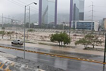
Damage was most evident in the Monterrey metropolitan area, which faced what Nuevo León governor Rodrigo Medina de la Cruz described as, "the worst weather phenomenon in its history.
[4] The National Hurricane Center (NHC) first mentioned the system as a candidate for tropical cyclone formation on June 20, while it was crossing the Windward Islands into the southeastern Caribbean Sea; at the time, some upper-level wind shear was present, leading to conditions only marginally favorable for development.
[8] By 18:00 UTC, a surface low-pressure area had formed about 105 miles (169 km) to the northeast of Cabo Gracias a Dios, Nicaragua, but due to a lack of persistent thunderstorm activity, it was not yet considered a tropical cyclone.
[9] Late on June 25, Hurricane Hunters verified the development of a surface low pressure area, which, combined with the increase of thunderstorm activity, indicated the system was a tropical depression.
[12] As Tropical Storm Alex progressed through the western Caribbean Sea towards the Yucatán Peninsula, it developed a large field of clouds accompanied by well-established outflow throughout its circulation.
Late on June 27, the storm emerged into the Gulf of Mexico with a large overall convective structure but little thunderstorm activity near the center due to the interaction with land.
[20] The circulation envelope of Alex remained very large, and by June 29, the storm's rainbands covered the entire western half of the Gulf of Mexico; rainfall was reported along the Texas and Louisiana coasts, even while the center was still several hundred miles offshore.
At 02:00 UTC on July 1, Alex made landfall at peak strength, with maximum sustained winds of 110 mph (180 km/h) and an unusually low central pressure of 946 millibars (27.9 inHg) in the municipality of Soto la Marina in the Mexican state of Tamaulipas.
[3] However, the interaction with the mountain range caused orographic lift on the eastern side of the storm after the low-level circulation center had ceased to exist, producing torrential rainfall throughout northern and central Mexico.
Thirteen shelters were opened in Reynosa,[36] twenty-two in Matamoros, and ten in San Fernando; a total of 3,000 people sought protection from the storm in the three municipalities.
The Jamaica Meteorological Service issued a flash flood warning for its entire island in response to the tropical wave producing thunderstorms across the nation.
Tarballs from the spill as large as apples washed onshore around Grand Isle, as well as other parts of Louisiana, Alabama and Florida,[61] from high storm tides created by the hurricane.
[58][63] On June 30, a mudslide knocked down a tree onto a 115-kV transmission line near El Vergel, causing 82 cities and towns in the municipalities of Villaflores and Villa Corzo to lose power; 32,000 residents were left without electricity from this outage alone.
[58] Prior to its second landfall, Alex caused one death in the state of Oaxaca when a wall collapsed on a dwelling in San Juan Chapultepec, killing the woman who was sleeping inside.
[58] The outer rainbands of Alex caused three deaths in Acapulco, Guerrero, after a retaining wall collapsed over the occupants of an improvised shack in a vacant lot.
[72] In Coahuila, the rainfall caused La Frakcjhuto release 35,000 cu ft/s (1,000 m3/s) of water into the Rio Grande, and Amistad Dam to reach 119% of normal operating capacity.
[109] Nationwide disruption in Internet connection and cell phone services was caused by damage to optical fibers, backbone nodes and telephonic central stations in Monterrey.
[114] In Coahuila, rainfall from Alex's remnants caused a small dam in an ejido in Castaños to overtop, forcing the evacuation of 50 people in the municipality's seat.
[116] Thousands of citizens in Ciudad Acuña were evacuated when the Arroyo Las Vacas flooded after 40 in (1,000 mm) of rain fell on nearby mountain ranges.
[116] In southern Texas, the feeder bands on the northern side of the hurricane began producing tropical-storm-force winds throughout Cameron, Willacy and Kenedy Counties starting on June 30.
[3] Following the storm's final landfall, Mexico's Secretariat of National Defense deployed 800 troops to Nuevo León and Tamaulipas under Plan DN-III-E to help aid operations.
[92] Mexican President Felipe Calderón requested adding resources to the federal disaster fund, as the $3 billion (2010 MXN; US$235 million) it held would not be sufficient to face the damage in Coahuila, Nuevo León and Tamaulipas.
[134] In the months following the storm, a total of $4.8 billion (2010 MXN; US$375 million) was released by the federal and state governments to aid in the reconstruction of the disaster areas in Nuevo León and Tamaulipas.
State governor Rodrigo Medina de la Cruz noted that the city of Monterrey had "collapsed due to the worst weather phenomenon in its history.
[142] Municipalities in the metropolitan area used contraflow during part of the day to re-establish traffic in sections where the arterial streets bordering the Santa Catarina River were damaged only in one direction.
[145] Kansas City Southern Railway reported it expected a net loss of five cents per share on its annual earnings due to the stoppage affecting its Mexican subsidiary.
Ford also idled production in its Oakville, Ontario assembly plant,[147] and suffered two-week delays in U.S. deliveries of its Fiesta model due to the rail track damage.
In areas where the storm's impact made it difficult to boil water due to the unavailability of gas or stoves, 70,000 jars with colloidal silver were distributed.
Additionally, laboratory testing of refuse coming from individuals with gastrointestinary illnesses commenced as a precaution to identify outbreaks of cholera and other diseases,[150] and over 82,000 vaccines were applied throughout the region.

Tropical storm (39–73 mph, 63–118 km/h)
Category 1 (74–95 mph, 119–153 km/h)
Category 2 (96–110 mph, 154–177 km/h)
Category 3 (111–129 mph, 178–208 km/h)
Category 4 (130–156 mph, 209–251 km/h)
Category 5 (≥157 mph, ≥252 km/h)
Unknown