Hurricane Paulette
The cyclone further strengthened as it moved away from the island, reaching its peak intensity with 1-minute sustained winds of 105 mph (169 km/h) and a minimum central atmospheric pressure of 965 mbar (28.5 inHg) on September 14.
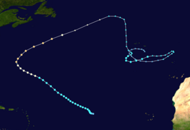
[5] The wave, which moved off the coast of West Africa on September 2, produced a large area of convection, or thunderstorms, over the Eastern Atlantic as it trekked westward.
[6] Despite this, the disturbance gained sufficient organization by 00:00 UTC on September 7 to be designated a tropical depression, about 1,160 miles (1,870 km) west of the Cabo Verde Islands.
[7][3] Late on that morning, an Advanced Scatterometer (ASCAT) pass indicated that the depression had begun to produce winds up to gale-force, warranting its upgrade to Tropical Storm Paulette 12 hours later.
[3] Paulette moved generally west-northwestward over the warm Atlantic waters and gradually strengthened on September 8, despite the presence of southwesterly wind shear and mid-level dry air in its vicinity.
[9][3] It sustained this intensity for roughly 12 hours before an upper-level trough strengthened wind shear, with its levels reaching as high as 50 mph (80 km/h), putting a halt to Paulette's intensification.
[3] As it exited its unfavorable environment the cyclone continued to intensify into September 12, nearing Category 1 hurricane strength and displaying an eye-like feature on visible satellite imagery.
[14] Paulette reached Category 2 strength on the Saffir–Simpson scale shortly before its large eye passed directly over, or made landfall, in Bermuda at 07:30 UTC on September 14 with estimated 1-minute sustained winds of 100 mph (160 km/h).
[3] Paulette reached its peak intensity after passing north of Bermuda with 1-minute sustained winds of 105 mph (169 km/h) and a minimum central pressure of 965 mb (28.5 inHg).
[15] By 12:00 UTC on September 16, Paulette completed its transition and became an extratropical cyclone about 350 nmi (400 mi; 650 km) southeast of Cape Race, Newfoundland over the cool waters of the Northern Atlantic, as it interacted with the baroclinic zone.
[17] The low gradually lost its frontal features as it continued moving southwards on September 19, while convection near the center became less sporadic and more organized.
[3] Deep convection continued to occur near the center of the storm as it drifted eastward and obtained an eye-like feature, where it reached its third and final peak intensity with winds of 60 mph (97 km/h) and a minimum central pressure of 1,002 millibars (29.6 inHg) at 06:00 UTC on September 22.
[18] However, very shortly afterward, cool sea surface temperatures and increasing wind shear took a toll on the system, therefore, its thunderstorms began to wane; soon after, Paulette became a post-tropical cyclone yet again at 12:00 UTC that day.
[3] Dry air and cool sea surface temperatures continued to cause the remnant low's circulation to erode, before it turned to the northwest and later took a sudden bend to the northeast, circling a high-pressure system.
[31] Several islands of Castle Harbour sustained significant erosion on cliffs, which caused some of the fortified walls to collapse, due to the heavy surf.
[33] Following the storm, Royal Bermuda Regiment soldiers were deployed to assess damage, clear roads, and provide assistance to affected locals.
Tropical storm (39–73 mph, 63–118 km/h)
Category 1 (74–95 mph, 119–153 km/h)
Category 2 (96–110 mph, 154–177 km/h)
Category 3 (111–129 mph, 178–208 km/h)
Category 4 (130–156 mph, 209–251 km/h)
Category 5 (≥157 mph, ≥252 km/h)
Unknown


