Hurricane Gert (2017)
Hurricane Gert was a strong tropical cyclone that brought heavy surf and rip currents to the East Coast of the United States in August 2017.
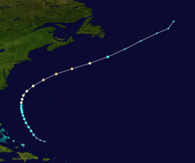
Thereafter, increasing vertical wind shear and decreasing sea surface temperatures caused Gert to rapidly weaken and transition into an extratropical cyclone on August 17, well east of Atlantic Canada.
The wave continued to track westwards over the next few days, eventually splitting into two systems—the northern one being the precursor to Gert, and the southern portion later spawning Hurricane Kenneth in the Eastern Pacific.
A surface low-pressure area developed on August 12, and a tropical depression formed at 18:00 UTC that same day 265 miles (426 km) northeast of the Turks and Caicos Islands.
At 18:00 UTC on August 16, Gert reached its peak intensity with winds of 110 mph (180 km/h) and a minimum central pressure of 962 mbar (962 hPa; 28.4 inHg), ranked as Category 2 on the Saffir–Simpson scale.
Compounded by increasing vertical wind shear and drier air,[6] Gert began to weaken and its cloud pattern rapidly deteriorated; the system degraded to a tropical storm by 12:00 UTC on August 17.
[9][11] In the Outer Banks off Cape Hatteras National Seashore, a 63-year-old man drowned on August 14 after being caught in a rip current during an attempt to rescue another swimmer "in distress".
[7] Ahead of the storm, Met Éireann issued yellow weather warnings for the entirety of Ireland, expecting heavy showers and localized flooding.
Tropical storm (39–73 mph, 63–118 km/h)
Category 1 (74–95 mph, 119–153 km/h)
Category 2 (96–110 mph, 154–177 km/h)
Category 3 (111–129 mph, 178–208 km/h)
Category 4 (130–156 mph, 209–251 km/h)
Category 5 (≥157 mph, ≥252 km/h)
Unknown
