Hurricane Leslie (2018)
Leslie became fully tropical and gradually intensified, becoming a Category 1 hurricane early on 3 October, and initially peaked with 1-minute sustained winds of 140 km/h (85 mph) later that day.
Leslie continued to slowly strengthen, reaching peak intensity with sustained winds of 150 km/h (90 mph) and a minimum central pressure of 968 mbar (28.59 inHg), early on 12 October.
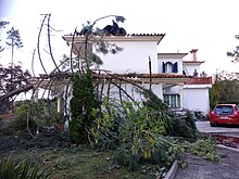
City, municipal, and the national government provided funds to repair damage to buildings as well as the local forests, and also launch cleanup efforts.
Leslie brought strong winds and torrential rainfall to Spain, most notably the Catalonia region, causing a river to spill its banks, nearly four dozen landslides to occur, and damaging several structures and vehicles.
The United States-based National Hurricane Center (NHC) began forecasting on 19 September 2018 that an extratropical low would form in a few days between the Azores and Bermuda.
[6][7] Amid favorable environmental conditions,[8] the system separated from the front, and its banding features became better established, signaling the formation of Subtropical Storm Leslie by 12:00 UTC on 23 September.
[5][10] Moderate vertical wind shear and dry air hindered the development of thunderstorm activity or convection outside the southeastern portion of the system, as it tracked generally southwestward.
As a result, Leslie became a tropical storm by 18:00 UTC on 29 September, while it was located approximately 1,850 km (1,150 mi) west-southwest of Flores Island in the Azores.
[5][18] Located within a region of cool sea surface temperatures and strong northwesterly wind shear,[18][19] the tropical storm intensified little during the next couple of days.
[5] Leslie's convection became more organized on 6 October, as banding features became more defined and a mid-level eye formed to the southeast of the storm's low-level circulation center.
[5][33] While the storm continued to track in a southeastward direction, traversing an environment of warmer sea surface temperatures and lower wind shear, a mid-level eye feature began to develop.
[5][36] Leslie peaked at 00:00 UTC on 12 October as a Category 1 hurricane, with maximum sustained winds of 150 km/h (93 mph) and a minimum central pressure of 968 mbar (28.6 inHg), while located approximately 1,065 km (662 mi) south-southwest of Flores Island.
[5][38] The mid-latitude westerly flow began to rapidly accelerate Leslie towards the east-northeast, with the cyclone passing 325 km (202 mi) north-northwest of Madeira Island around 06:00 UTC on 13 October.
[5] Shortly after, Leslie began to transition into an extratropical cyclone, as colder air entered from the south and west and the system's mid-level eye decayed.
The latter helped to spawn a surface low over the Mediterranean Sea which increased convection near the cold front, and it provided unstable air parcels, reduced evaporation, and added moisture to the mid-levels of the airmass over France.
An orange alert was issued for the provinces of Barcelona, Castellón, Huesca, Lleida, Navarra, Tarragona, Teruel, Zaragoza, Girona, and the Balearic Islands.
[67] The Aude, Hérault, Pyrénées-Orientales, Tarn, Haute-Garonne, and Aveyron departments in France were all placed under an orange alert, due to the expectation of strong winds and flooding rainfall from the approaching Leslie.
[113] The European women's roller hockey championship, which was taking place in Mealhada, was stopped in its final minutes after the roof of the sports facility was damaged, windows shattered, and debris littered the track.
[124] Leslie brought torrential rainfall and flooding to the autonomous communities of Andalusia, Catalonia, Castilla-La Mancha, the Balearic Islands, and Valencia.
[129][130] Girona and Barcelona experienced 14,000 power outages and 12 roads were impassable due to floodwaters; the latter forced the suspension of school transportation services for six municipalities.
The United States Coast Guard and the crew considered towing the ship, but ultimately abandoned it due to the nearby Hurricane Leslie.
[150] From late September through early October, Leslie brought high surf to the East Coast of the United States, inducing the highest swell observed in some locations for years.
Leslie also generated the single-longest period of tropical swells observed in the Outer Banks in the last 20 years, producing surf at chest height or higher.
[151] Leslie and a low-pressure system inhibited a trough from tracking eastward from 29 to 30 September, causing fog to persist for 32 hours in Ferryland, Newfoundland.
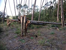
[154][156] Around 80 percent of the trees planted in pine forests along the coast of Leiria, in areas heavily affected by wildfires and Leslie, died.
[102] Authorities activated the emergency municipal plan in Montemor-o-Velho, Figueira da Foz, Condeixa-a-Nova, Soure, Coimbra, and Mira to aid with cleanup and relief efforts.
[163] Fisheries near Figueira da Foz operated at below normal capacity through 2020, due to a reduction in sardine supply that occurred after Leslie moved through the area.
[164] Although the Portuguese government agreed to cover 70 percent of the costs of reconstruction for the Equestrian Center of Montemor-o-Velho, it had not provided the funds two years post-storm.
[172] Social organizations that experienced large financial woes had not received relief funding from the Portuguese government two years after the storm.
[174] The Coimbra City Council approved a measure on 30 June to repair the Celas Integrated Sports Center and a building at the Campo Municipal da Arregaça, both of which were severely damaged by Leslie.

Tropical storm (39–73 mph, 63–118 km/h)
Category 1 (74–95 mph, 119–153 km/h)
Category 2 (96–110 mph, 154–177 km/h)
Category 3 (111–129 mph, 178–208 km/h)
Category 4 (130–156 mph, 209–251 km/h)
Category 5 (≥157 mph, ≥252 km/h)
Unknown