Hurricane Lili
[3] In the United States, the storm cut off the production of oil within the Gulf of Mexico, and caused severe damage in parts of Louisiana.
[6] The cyclone continued to intensify as it moved west through the Caribbean Sea, reaching an initial peak strength of 70 mph (110 km/h) on the morning of September 24.
[1][12] The system turned to the northwest and sped up, becoming a major hurricane on October 2 while 365 miles (587 km) south-southeast of New Orleans.
[13] This intensification continued, aided by warm sea surface temperatures in the Gulf of Mexico and good outflow.
The storm began to quickly weaken in the early morning hours of October 3,[16] and this rapid weakening continued until the hurricane's final landfall near Intracoastal City, Louisiana, due to a combination of vertical wind shear, cool waters just offshore Louisiana,[17] and slowly encroaching dry air within its southwest quadrant.
[1] The system continued inland, curving to the north-northeast, and dissipated when absorbed by an extratropical low near the Arkansas/Tennessee border on October 6.
[1] Over the next week, the islands of Hispaniola, Jamaica, Cuba, the Caymans, and the Yucatán Peninsula were all under advisories of some kind at different times.
[1] Hurricane and tropical storm watches were issued for the Gulf Coast on October 1, and were upgraded to warnings the next morning.
Military officials at the Guantanamo Bay detention camp prepared for the possibility of evacuating their Al Qaeda and Taliban prisoners.
[22] A total of 130,000 Cuban citizens, mainly in western portions of the island, evacuated their homes prior to the storm.
[23] Significant action was taken along the Gulf Coast as the threat the storm posed, predicted to come ashore at Category Four strength, became more urgent.
[2] Near total loss of electricity, water, and telephone services occurred, and utility systems were heavily damaged.
Several hundred homes and two schools were damaged, and the Rose Hall Police Station's roof was lost.
[1] The storm's major impact was extremely heavy rainfall, in excess of 16 inches (410 mm) near the settlement of Camp-Perrin, Haiti.
Wind gusts in excess of 70 mph (110 km/h) and rainfall over 2 feet (0.61 m) resulted in damage to homes, crops, and utility systems.
[45] Lili made landfall as a category two hurricane twice in Cuba, on the Isle of Youth and in the Pinar del Río Province, on October 1.
Wind gusts up to 112 mph (180 km/h) and rainfall amounts reaching 6 inches (150 mm) in some places caused damage to homes, businesses and crops.
[46] The tobacco and rice crops were badly depleted, but it was difficult to differentiate how much damage was caused by Lili, since Isidore had struck the region just a week earlier.
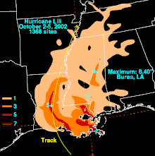
[1] Wind gusts reaching 120 mph (190 km/h), coupled with over 6 inches (150 mm) of rainfall and a storm surge of 12 feet (3.7 m) caused over $790 million (2002 USD) in damage to Louisiana.
No direct deaths were reported as early warnings and the compact nature of the storm circumvented major loss of life.
Wind gusts in excess of 120 mph (190 km/h), along with a storm surge of 12 feet (3.7 m) dealt major damage to nearly 4000 homes.
[49] The worst storm surge flooding occurred in Intracoastal City, destroying 20 buildings owned by a helicopter company.
[49] Lili's outer rainbands dumped large amounts of rain and brought tropical storm force wind gusts to Mississippi.
Minor power outages occurred, mainly in southern Mississippi, and combined with the flooding of roads and buildings caused $30 million (2002 USD) in damage.
[1] Hurricane Lili's remnants brought heavy rainfall, peaking at four inches in Arkansas, to the Southeast, before dissipating near the Arkansas-Tennessee border.
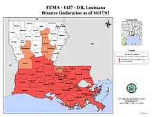
[1] President Bush declared Louisiana a federal disaster area after the storm, making it eligible for assistance.
[56][57] Seven states sent tree trimmers to help clear debris from power lines and roads to speed the recovery process.
[58] In addition, FEMA gave SLEMCO, the state's power company, an $8.6 million grant, which paid for 75% of the damage to the electrical grid there.
[61] Due to the widespread and heavy damage caused by the hurricane, the World Meteorological Organization retired the name Lili in the spring of 2004.

Tropical storm (39–73 mph, 63–118 km/h)
Category 1 (74–95 mph, 119–153 km/h)
Category 2 (96–110 mph, 154–177 km/h)
Category 3 (111–129 mph, 178–208 km/h)
Category 4 (130–156 mph, 209–251 km/h)
Category 5 (≥157 mph, ≥252 km/h)
Unknown