1938 New England hurricane
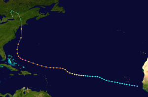
[10] The storm developed into a tropical depression on September 9 off the coast of West Africa, but the United States Weather Bureau was unaware that a tropical cyclone existed until September 16 when ships reported strong winds and rough seas 350 miles northeast of San Juan; by then, it was already a well-developed hurricane and had tracked westward toward the southeastern Bahamas.
[note 1] The storm was propelled northward, rapidly paralleling the East Coast before making landfalls on Long Island, New York and Connecticut as a Category 3 hurricane on September 21, with estimated sustained winds of 115–120 mph.
It was inferred to have reached hurricane intensity over the central Atlantic by September 15,[15] though ship observations became increasingly sparse as the cyclone tracked farther away from land.
[14] The first definitive indication of a tropical cyclone at sea was a report from the Brazilian ship SS Alegrete which documented a barometric pressure of 958 mbar (hPa; 28.29 inHg) within hurricane-force winds on September 17.
[16] The hurricane continued to slowly strengthen and track westward at around 20 mph (32 km/h) about the southern periphery of a subtropical ridge centered over the Bermuda.
[17] At 18:00 UTC (2 p.m. EST) on September 19, the tropical cyclone strengthened further into a Category 5-equivalent hurricane with sustained winds of 160 mph (260 km/h) while north of the Turks and Caicos;[15] this figure remained unchanged in reanalysis and serves as the storm's peak strength, although the reanalysis project noted that "considerable uncertainty" remains regarding the magnitude of the storm's maximum intensity at sea.
Normally, tropical cyclones approach the eastern Bahamas then slowly recurve north and northeast off the United States East Coast and move out to sea.
When the storm turned north, the office issued warnings for the Carolina coast and transferred authority to the bureau's headquarters in Washington.
Both the Jacksonville and Washington, DC offices expected the cyclone to reach the ocean off North Carolina and then head harmlessly out to sea.
A noon meeting was called and Pierce presented his conclusion, but he was overruled by "celebrated" chief forecaster Charles Mitchell and his senior staff.
The Washington office issued an advisory saying that the storm was 75 mi (120 km) east-southeast of Atlantic City and would pass over Long Island and Connecticut.
Re-analysis of the storm suggests that the hurricane was farther north and just 50 mi (80 km) from Fire Island, and that it was stronger and larger than the advisory stated.
[28] Freshwater flooding was minimal, however, as the quick passage of the storm decreased local rainfall totals, with only a few small areas receiving over 10 inches (250 mm).
Due to the lack of technology in 1938, Long Island residents were not warned of the hurricane's arrival,[31] leaving no time to prepare or evacuate.
However, Yale had a backup forest at Great Mountain in northwestern Connecticut which was spared from the totality of the damages, and they were able to keep their forestry program running, which maintains operation today.
[34] The western side of the hurricane caused sustained tropical storm-force winds, high waves, and storm surge along the Jersey Shore[35] and destroyed much of the boardwalk in Atlantic City.
[36] The surge inundated several coastal communities; Wildwood was under 3 feet (1 m) of water at the height of the storm, and the boardwalk was destroyed in Bay Head and dozens of cottages washed into the ocean.
[39] During the hurricane, starting before it hit and continuing after, a citywide trucker strike occurred across both NYC and New Jersey, this led to some complications to the relief effort.
[41][42][43] In Manhasset Bay, almost 400 boats were ripped from their moorings and smashed or sunk, with more than 100 washing up on the beach by the Port Washington Yacht Club.
The wife of New York City mayor Fiorello La Guardia was forced to wait out the storm on the second floor of their Northport cottage.
[3][40][45][46][47][48] The orientation of Eastern Long Island facing due south, made it extremely exposed to the storm surge and intense winds.
So extensive was the storm surge and overwash on eastern Long Island, that rescue works had to use utility maps to figure out were roads and homes had been.
[51] Mobs looted stores in downtown Providence, often before the flood waters had fully subsided and due in part to the economic difficulties of the Great Depression.
Napatree Point was completely swept away, a small cape that housed nearly 40 families between the Atlantic Ocean and Little Narragansett Bay just off of Watch Hill.
[51] A few miles from Conanicut Island, Whale Rock Light was swept off its base and into the waves, killing lighthouse keeper Walter Eberle.
Light keeper George T. Gustavus was thrown free from the wreckage of the house and was saved by an island resident who held a branch into the water from the cliffs farther down the coast.
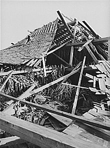
Small shoreline towns to the east of New Haven experienced much destruction from the water and winds, and the 1938 hurricane holds the record for the worst natural disaster in Connecticut's 350-year history.
New London was first swept by the winds and storm surge, after which the waterfront business district caught fire and burned out of control for 10 hours.
Interior sections of the state experienced widespread flooding as the hurricane's torrential rains fell on soil already saturated from previous storms.
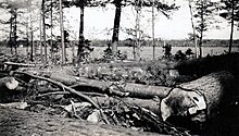
As in Vermont, very high winds brought down numerous trees and electric lines, but rainfall totals in New Hampshire were significantly less than those in other states.
Tropical storm (39–73 mph, 63–118 km/h)
Category 1 (74–95 mph, 119–153 km/h)
Category 2 (96–110 mph, 154–177 km/h)
Category 3 (111–129 mph, 178–208 km/h)
Category 4 (130–156 mph, 209–251 km/h)
Category 5 (≥157 mph, ≥252 km/h)
Unknown